
NOAA now sees a 75% chance that the 2026 El Nino will become stronger than any event in its modern record.
The September 10 ENSO Diagnostic Discussion puts the key period between October and December. NOAA says there is a 75% chance that the three-month Relative Oceanic Nino Index, or RONI, will reach +2.5°C or higher.
The same NOAA update gives a greater than 90% chance of a “very strong” El Nino during fall and winter 2026 to 2027. That broader category begins at a lower threshold than +2.5°C, so the two numbers are not competing forecasts. The 75% figure refers to the stricter record-breaking threshold.
The Number NOAA Is Watching Is +2.5°C
RONI tracks temperature changes in the Nino 3.4 region of the equatorial Pacific while accounting for temperatures across the wider tropical oceans.
The +2.5°C threshold matters because the strongest previous events did not reach it. NOAA’s historical RONI data show peaks of +2.3°C during both the 1997/98 and 2015/16 El Nino events.
| El Nino event | RONI peak |
|---|---|
| 1997/98 | +2.3°C |
| 2015/16 | +2.3°C |
| 2026 NOAA record threshold | +2.5°C or higher |
NOAA is effectively putting three-to-one odds on 2026 beating the two strongest RONI peaks in its record.
The Pacific Is Already Showing Extreme Warmth

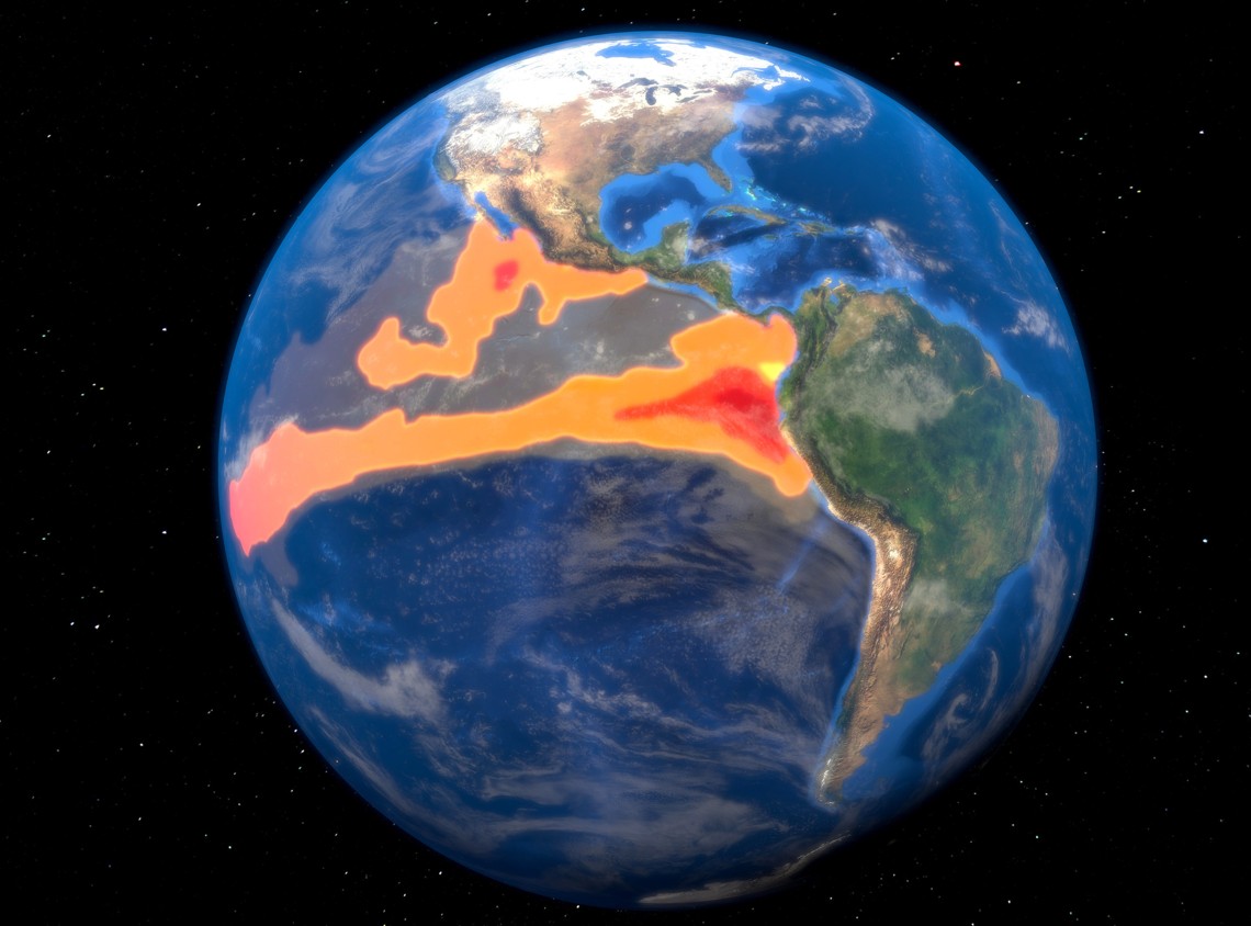
The eastern Pacific is running hottest. NOAA reported Niño 1+2 at +3.4°C in August and Niño 3 at +2.5°C. The central Niño 3.4 region, the area used for RONI, was already at +1.8°C and still warming.
The heat reaches well below the surface too. NOAA reported widespread subsurface anomalies above +10°C in parts of the equatorial Pacific, along with stronger westerly winds and heavier convection farther east.
That combination is more important than one hot patch of water. The ocean and atmosphere are reinforcing each other, which is the pattern forecasters expect during a strengthening El Nino.
All 30 NOAA Experimental Model Runs Still Point to a Major Event
Video: Background on the developing 2026 El Nino and the Pacific conditions behind it.
NOAA’s Geophysical Fluid Dynamics Laboratory published its September SPEAR forecast on September 8 using 30 separate simulations.
All 30 still put the coming peak in the same league as the strongest El Nino events in the historical record. GFDL also says the September forecast is weaker than the August run, so the models have backed off somewhat rather than simply climbing higher with every update.
The laboratory does not publish a clean table with the exact peak from each of the 30 runs. Its chart is still useful because the lines remain tightly grouped through the coming winter, then spread much farther apart by spring 2027.
That is the point where confidence drops. GFDL says most of the runs show below-average Pacific temperatures by next summer, but the path to that reversal is much less certain than the expected late-2026 peak.
WMO Expects the Peak Near the End of the Year
The World Meteorological Organization reached the same broad conclusion in its Global Seasonal Climate Update published September 3.
Its multi-model forecast puts the average Niño 3.4 sea surface temperature anomaly near +3.6°C for September through November, with the event expected to peak around November or December.
The +3.6°C figure is not directly comparable with NOAA’s RONI because the two measures use different baselines. Both still point to an exceptionally warm tropical Pacific.
WMO also expects a positive Indian Ocean Dipole near +0.9°C during the same season. That matters because it can shift rainfall across Africa, Asia and Australia at the same time El Nino is doing the same from the Pacific.
What a Record El Nino Could Mean for Weather
Video: How El Nino shifts rainfall and storm patterns between different parts of the world.
A strong El Nino tilts the odds in different directions depending on the region. The southern United States usually gets a wetter winter, while Indonesia and parts of the western Pacific face a greater risk of dry conditions.
The United States has already endured major heat in 2026, adding another chapter to the highest temperatures ever recorded in each state.
A record RONI reading would not guarantee record heat everywhere. Storm tracks, soil moisture and conditions in the Atlantic and Indian oceans still decide what happens locally.
Rainfall Could Cause More Trouble Than the High Temperature
For southern Africa, Australia and parts of Asia, the bigger story may be rainfall rather than the +2.5°C headline.
WMO’s September outlook expects a positive Indian Ocean Dipole near +0.9°C, which can reinforce dry conditions in parts of Australia and Southeast Asia while shifting rainfall toward parts of eastern Africa.
Long dry periods can cut crop production, lower reservoirs and worsen wildfire conditions. Heavy rain in other regions can bring floods, landslides and damage to roads and farmland.
In its September 23 health warning, WMO also told governments to prepare for heat illness, wildfire smoke, food insecurity, cholera, malnutrition and diseases affected by changing mosquito populations.
A 75% Chance of Record Strength Does Not Mean Record Damage Everywhere
NOAA’s 75% figure applies only to the strength of El Nino as measured by RONI. It is not a 75% chance of record drought, flooding or heat around the world.
The stronger the event becomes, the better the odds of seeing recognizable El Nino patterns. Local outcomes can still turn out very differently because the Atlantic, Indian Ocean and shorter-lived weather systems are changing at the same time.
El Nino Could Fade Quickly in 2027
NOAA’s September ENSO probability table keeps El Nino at 100% through January to March 2027. The probability then falls to 97% for February through April, 82% for March through May and 43% for April through June.
The experimental SPEAR runs go further, with most simulations showing equatorial Pacific temperatures below average by summer 2027.
A fast turnaround has happened before. NOAA’s review of the 1997/98 event says very strong El Nino conditions lasted into early May 1998 before Pacific temperatures turned below normal. La Nina was established by July.
That does not mean 2027 will repeat 1998. It does show that an extreme El Nino can collapse within months once the Pacific starts moving the other way.
October 8 Is the Next Test
NOAA’s next ENSO update is scheduled for October 8. One number will matter most: the chance that October through December still reaches +2.5°C or higher.
If that probability stays near 75% or rises, and the Pacific winds keep strengthening, the record forecast remains on track. If the +2.5°C probability falls and the ocean begins warming more slowly, the record case weakens.
The line is clear. The previous RONI record is +2.3°C. NOAA currently gives 2026 a 75% chance of going past +2.5°C.