
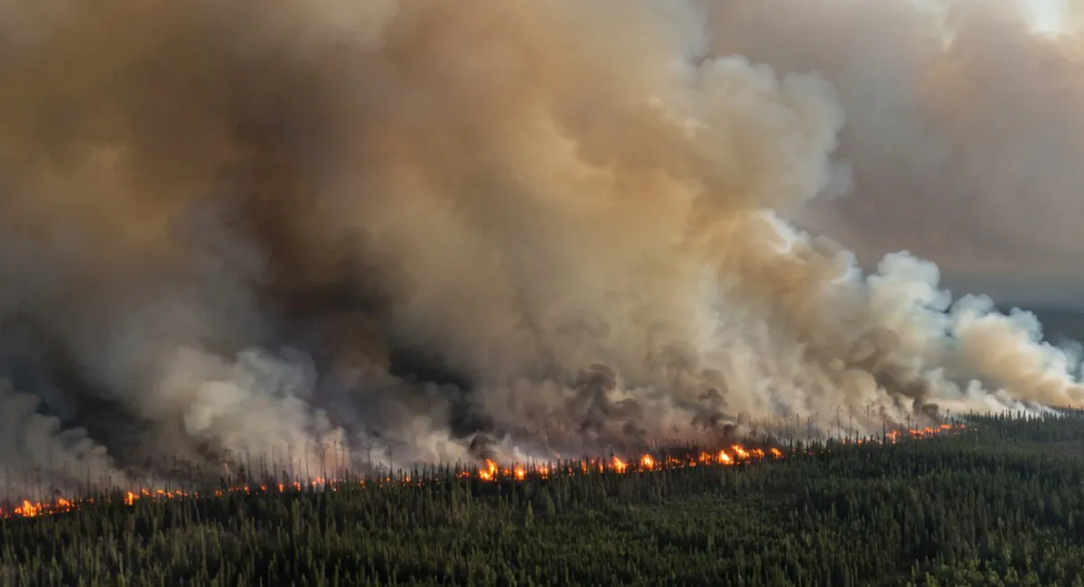
Canada is facing a serious surge in wildfire activity, with more than 800 active fires reported nationwide on July 15. Dozens of new fires appeared in a single day, and some of the most aggressive burning is now concentrated in western Ontario.
The smoke is spreading through Minnesota, Michigan, Wisconsin and New York before moving farther into the Northeast.
Air quality alerts now cover areas from the Upper Midwest to parts of New England. Northeastern Minnesota faces the harshest conditions, with officials warning that pollution could reach levels considered hazardous for everyone.
Wildfire smoke has also entered the wider political dispute, although the 50% tariffs Trump imposed on selected Canadian goods were officially based on separate complaints involving vehicles, alcohol and dairy.
Table of Contents
ToggleWhat We Know Right Now
- More than 800 wildfires were active across Canada on July 15.
- Western Ontario is producing a large share of the smoke entering the United States.
- Minnesota is also fighting major fires that are adding smoke near the border.
- Air quality alerts cover parts of Minnesota, Michigan, Wisconsin, New York and New England.
- Smoke may reach Detroit, Milwaukee, New York City, Boston, Philadelphia and Washington.
- Flames crossing into major U.S. population centers are not the main threat.
- Fine-particle pollution can travel hundreds or thousands of miles from a fire.
How Serious Are the Canada Wildfires?
The national fire count is high enough to strain crews, aircraft and emergency systems across several provinces. Canada is not dealing with one enormous fire. It is dealing with hundreds of incidents spread across a vast area.
The official Canadian Wildland Fire Information System map showed more than 800 active fires on Wednesday. The figure changes throughout the day as new fires are detected and other incidents are brought under control.
Ontario has become one of the main areas of concern. A burst of new fires developed during hot and dry weather, including incidents near Lake Nipigon and the Armstrong area of northwestern Ontario.
Conditions near Armstrong became dangerous enough to stop freight trains. Crews were removed after flames surrounded sections of track. The incident illustrates how quickly a remote forest fire can become a threat to workers, transportation lines and communities.
Canada uses five national preparedness levels to describe pressure on firefighting resources. The Canadian Interagency Forest Fire Centre publishes the latest national level, fire totals and requests for assistance. A high preparedness level means several regions are competing for aircraft, personnel and equipment.
The Number of Fires Does Not Tell the Whole Story
A small fire close to a town can be more dangerous than a much larger fire in an isolated forest. Wind, fuel dryness, road access and distance from homes all affect the threat.
Some northern communities have only one road or depend heavily on aircraft. An evacuation becomes harder when smoke limits visibility or fire damages electricity and communications infrastructure.
Indigenous communities face particular risk because many are remote and have limited emergency housing nearby. A fire that would trigger an ordinary road evacuation in southern Canada may require military aircraft and long-distance relocation in the north.
Can the Fires Spread Into the United States?
A Canadian wildfire can physically cross the international border when it burns close enough to it. Forests do not stop at a political line. Fire crews in both countries regularly coordinate on incidents near the border.
I would not describe the current situation as Canadian flames advancing toward major U.S. cities. Most of the largest Canadian fires are too far north for that. The more realistic cross-border danger is smoke.
Wildfire smoke can rise high into the atmosphere and travel for days. Wind can carry it through several states before bringing the pollution back to ground level.
| Threat | Current U.S. Risk | Areas Most Exposed |
|---|---|---|
| Fire crossing the border | Localized | Remote forest areas near Canada |
| Dense surface smoke | High in some regions | Minnesota and the Upper Great Lakes |
| Elevated fine-particle pollution | Expanding | Midwest, Great Lakes and Northeast |
| High-altitude haze | Widespread | Parts of the eastern United States |
| Reduced visibility | Possible | Areas beneath the densest smoke plume |
Minnesota Is Dealing With Both Canadian Smoke and Local Fires
Not every plume entering the Midwest comes from Canada. Large fires in northern Minnesota are adding their own smoke close to the ground.
Minnesota issued an extended air quality alert covering the Twin Cities, Alexandria, Duluth, Two Harbors and Grand Portage. Northeastern sections of the state could enter the hazardous category, where officials advise everyone to reduce exposure.
Michigan also issued air quality warnings as smoke moved over the Upper Peninsula and into the Lower Peninsula. Wisconsin and New York expected worsening conditions as the plume traveled east.
The FireSmoke Canada forecast provides a useful view of predicted smoke movement across both countries. Forecasts can change quickly when wind direction or fire behavior shifts.
Smoke Is the Main Danger for Americans
The most harmful component of wildfire smoke is PM2.5. The particles are less than 2.5 micrometers wide and can move deep into the lungs. Some can enter the bloodstream.
Exposure can cause burning eyes, coughing, headaches, chest discomfort and shortness of breath. People with asthma, chronic obstructive pulmonary disease or heart disease face a higher risk of serious complications.
Children breathe more air relative to their body size and spend more time outdoors. Older adults may have medical conditions that make it harder to tolerate smoke. Pregnant women and outdoor workers also need to take greater care.
The connection between polluted air and hospital care is examined in our report on air quality and asthma hospitalizations. Smoke can create an immediate increase in breathing problems even hundreds of miles from the fire.
A Hazy Sky Does Not Always Mean Dangerous Air at Ground Level
Smoke can remain high in the atmosphere and turn the sun orange without producing extreme pollution where people are breathing. Another plume may look less dramatic but settle near the surface and create unhealthy conditions.
The color of the sky is therefore a poor safety test. The Air Quality Index gives a more useful reading.
Residents can check local measurements through the official AirNow map. Conditions may differ sharply between neighboring counties and can change within hours.
| AQI | Category | What It Means |
|---|---|---|
| 0 to 50 | Good | Air pollution presents little risk. |
| 51 to 100 | Moderate | Unusually sensitive people may notice symptoms. |
| 101 to 150 | Unhealthy for sensitive groups | Children, older adults and people with heart or lung disease should reduce prolonged activity. |
| 151 to 200 | Unhealthy | Everyone may begin to experience health effects. |
| 201 to 300 | Very unhealthy | Health warnings apply to the full population. |
| Above 300 | Hazardous | People should avoid outdoor exposure as much as possible. |
What People in the Smoke Zone Should Do
Closing windows can help when outdoor air deteriorates. Air conditioning should be set to recirculate indoor air when the system allows it. A portable cleaner with a HEPA filter can reduce particles inside a room.
Ordinary cloth and surgical masks provide limited protection from fine smoke particles. A properly fitted N95 or KN95 respirator offers greater protection during unavoidable outdoor activity.
Exercise increases the amount of air drawn into the lungs. Running, cycling and outdoor sports should be moved indoors or postponed during unhealthy conditions.
The U.S. Environmental Protection Agency provides detailed guidance for periods of wildfire smoke, including advice on indoor filtration and respirator use.
Anyone experiencing severe breathing difficulty, chest pain or confusion should seek medical help rather than waiting for the smoke to clear.
Could Conditions Become Worse?
Yes. Heat, dry vegetation and wind can produce rapid fire growth. Lightning can start dozens of additional fires within a few hours, including in places that are difficult for crews to reach.
Rain could slow the fires, but scattered storms are not always enough. Thunderstorms may bring strong wind and lightning without delivering sustained rain to the burning area.
Smoke conditions in the United States will depend heavily on wind direction and atmospheric height. A shift in the weather can move the main plume away from one state and into another.
New York City, Boston and Philadelphia may see smoke and haze as the plume moves east. Current forecasts do not guarantee a repeat of the extreme orange skies seen in New York during 2023, but surface pollution could still reach unhealthy levels in parts of the region.
The Bottom Line
Canada is dealing with a broad and dangerous wildfire outbreak. More than 800 fires are active, new incidents are developing quickly and western Ontario is sending a substantial smoke plume toward the United States.
The flames are not expected to sweep into major American cities. Smoke is already crossing the border and poses the larger danger. Minnesota and the Great Lakes region face the most immediate exposure, with haze and fine-particle pollution spreading toward the Northeast.
People should follow measured air quality rather than judging conditions by smell or the color of the sky. AirNow, Canadian fire maps and local health alerts provide a clearer picture than social media photographs.
Previous disasters, including the destructive Los Angeles wildfires, have shown how quickly heat, wind and dry vegetation can turn a manageable fire into an emergency. Canada is not facing one isolated blaze. It is facing hundreds, and their smoke has already made the crisis an American public health issue.
Related Posts:
- Los Angeles Wildfires Leave 24 Dead, Thousands…
- Social Security Now Lets People Track Disability…
- Scientists Just Found a Dangerous 1,000-Year Flaw in…
- Top 5 Most Dangerous Intersections in Chicago by Crash Data
- 26 Most Dangerous Cities in the World 2025 - Where…
- Canada Imposes Tariffs of Up to 50% on $19.9 Billion…