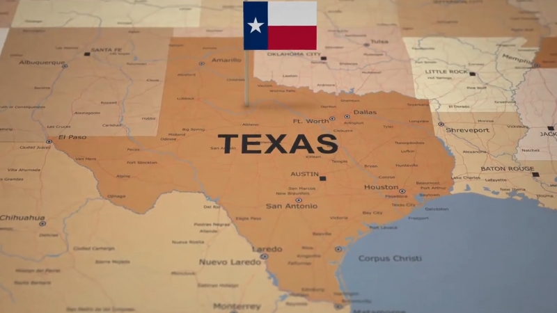
Texas, one of the 50 U.S. states, is in the south-central region of the country.
It has a 350-mile coastline along the Gulf of Mexico to the southeast and shares a 1,969-mile border with Mexico, with the Rio Grande River marking the boundary with the Mexican states of Chihuahua, Coahuila, Nuevo León, and Tamaulipas.
The state borders New Mexico to the west, Oklahoma to the north (separated by the Red River), Arkansas to the northeast, and Louisiana to the east, divided by the Sabine River.
Major rivers in Texas include the Brazos, Canadian, Colorado, and Pecos rivers.
Texas is notable for its vast landscapes, large cattle ranches, the iconic Texas longhorn breed, frequent tornadoes, the tragic assassination of President Kennedy, and Houston’s role in U.S. space exploration.
Table of Contents
ToggleTexas State Map and Satelite View
Texas was once part of Mexico and gained independence in 1836, forming the Republic of Texas.
It joined the United States through annexation and was admitted as the 28th state on December 29, 1845, officially ceding its sovereignty to the U.S. on February 14, 1846.
Covering 696,241 km² (268,581 sq mi), Texas is the largest state in the contiguous U.S., approximately twice the size of Germany and slightly larger than Afghanistan.
Compared to Alaska, Texas is about 2.5 times smaller.
The state is divided into 254 counties.
Geography Map
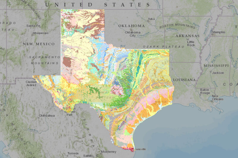
Texas is the second-largest state in the U.S. by both area and population, covering 268,596 square miles (695,662 km²).
Its vast landscapes range from coastal plains to deserts, with rich geographical diversity that defines its regions and character.
Situated in the south-central part of the country, Texas is bordered by New Mexico to the west, Oklahoma to the north, Arkansas and Louisiana to the east, and Mexico to the south, with the Gulf of Mexico lying to its southeast.
Major Regions
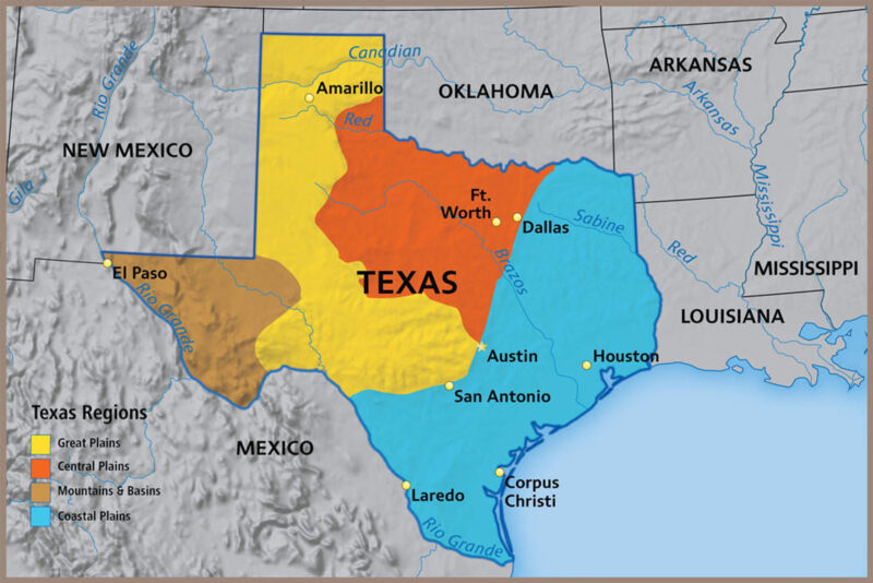
Texas is typically divided into four main regions: the Gulf Coastal Plains, Interior Lowlands, Great Plains, and Basin and Range Province.
1. Gulf Coastal Plains
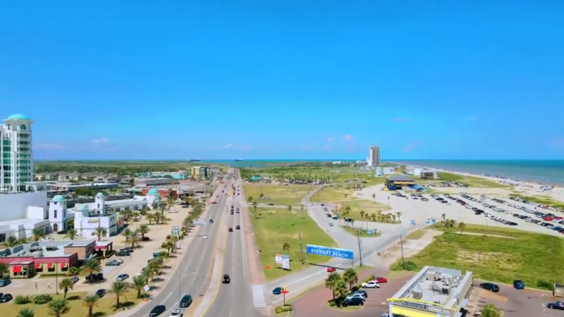
The Gulf Coastal Plains stretch along the eastern and southeastern part of Texas, bordering the Gulf of Mexico.
Known for its flat, fertile lands and humid climate, this region includes major cities like Houston, Corpus Christi, and Galveston.
Its coastal areas are marked by marshes, barrier islands, and estuaries, while inland, the land gives way to pine forests and prairie.
Agriculture thrives here due to the fertile soil, and the area is a key hub for oil, shipping, and petrochemical industries.
2. Interior Lowlands
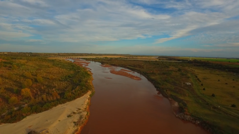
Located in north-central Texas, the Interior Lowlands include rolling prairies and wooded areas.
This region is known for cattle ranching, a legacy of Texas’s deep-rooted cowboy culture.
Major rivers, including the Red River, flow through these lands, supporting agriculture and providing a water source for cities like Fort Worth and Abilene.
The lowlands experience a mix of continental and subtropical climates, with relatively mild winters and hot summers.
3. Great Plains
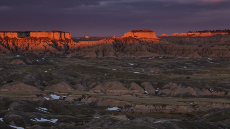
The Great Plains stretch across northern and central Texas, spanning the Panhandle and parts of central Texas.
This region is characterized by high plateaus, prairies, and grasslands, making it suitable for farming and ranching.
Amarillo and Lubbock are major cities here, with agricultural products like wheat, cotton, and cattle driving the economy.
The Great Plains experience a semi-arid climate, with hot summers and cold winters, and are prone to dramatic weather patterns, including tornadoes.
4. Basin and Range Province
Super bloom of desert gold (Geraea canescens) at Lake Hill, Panamint Valley, Death Valley National Park pic.twitter.com/B8OqstNtk9
— Basin & Range Watch (@BasinRange) April 4, 2024
West Texas is home to the Basin and Range Province, a region that includes the notable Guadalupe Mountains, where Guadalupe Peak—Texas’s highest elevation at 2,667 meters (8,749 feet)—is located.
Another prominent feature within this region is the Davis Mountains, also known as the Limpia Mountains, a volcanic-origin mountain range.
Spanning a large part of West Texas, the Chihuahuan Desert extends into eastern Mexico and also covers parts of the middle and lower Rio Grande Valley.
Rivers, Lakes and Waterways
Texas is traversed by numerous rivers, the longest of which is the Rio Grande.
It stretches over 1,896 miles (3,051 km) along the Texas-Mexico border, providing a natural boundary and essential water source.
Other significant rivers include the Red River, which defines the border with Oklahoma; the Brazos River, which runs through central Texas; and the Colorado River, which flows into the Gulf of Mexico near Matagorda Bay.
It also has few natural lakes but many reservoirs created for water storage, flood control, and recreation.
Toledo Bend Reservoir on the Texas-Louisiana border and Lake Texoma on the Texas-Oklahoma border are two of the largest.
Sam Rayburn Reservoir in East Texas, Lake Travis near Austin, Amistad Reservoir on the Rio Grande, Lake Buchanan in the Texas Hill Country, and Possum Kingdom Lake along the Brazos River are notable as well.
National Parks
Texas is home to diverse national parks, each offering unique landscapes and historical significance.
Big Bend National Park showcases dramatic canyons, desert flora, and vast night skies, making it a haven for birdwatchers and outdoor enthusiasts.
Guadalupe Mountains National Park features the highest peaks in Texas, with striking desert and mountain views, as well as rich fossil history.
Padre Island National Seashore protects one of the longest undeveloped barrier islands in the world, teeming with marine life and coastal habitats.
Finally, San Antonio Missions is a UNESCO World Heritage Site, preserving 18th-century Spanish missions and offering insight into Texas’s early colonial history.
Climate and Time Zones
The eastern part of the state has a humid subtropical climate, supporting forests and farmland.
Moving westward, the climate shifts to semi-arid in the central and Great Plains regions and becomes desert-like in the western Basin and Range.
Texas also experiences severe weather, with tornadoes common in the north and hurricanes affecting the coastal areas.
Texas experiences long, warm summers with extended clear skies.
The main rainy season is in spring (March to May) and sometimes early fall (September to October) as the seasons shift. Rain showers are typically brief but intense, with rainy spells lasting one to two days.
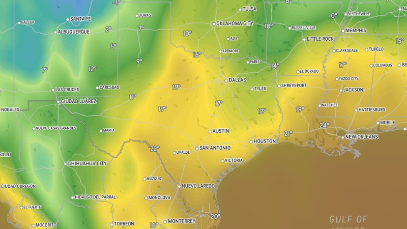
Winters are generally mild, though the state’s large size creates a temperature difference of about 20 degrees between northern and southern areas.
The southern Rio Grande Valley usually stays in the 60s and 70s during winter.
Texas Spans Two Time Zones
All 254 counties in Texas, spanning two time zones and encompassing 260,000 square miles of diverse ecosystems, are vulnerable to challenges posed by manmade climate change. https://t.co/WEdmtypDpW
— Truthdig (@Truthdig) September 15, 2024
Central Time (CT) and Mountain Time (MT).
Most of the state observes Central Time, while three counties in the western region—El Paso, Hudspeth, and parts of Culberson—use Mountain Time.
During Daylight Saving Time, these areas switch between Central Daylight Time (CDT) and Central Standard Time (CST) for most of Texas, and Mountain Daylight Time (MDT) and Mountain Standard Time (MST) in the western counties.
Population Heat Map
Texas, located in the South Central U.S. along the border with Mexico, is the largest of the contiguous 48 states. It has a population growth rate of 1.8%, ranking 3rd in the nation according to World Population Review.
At the time of the 2010 Census, Texas had a population of 25,145,561, making it the second most populous U.S. state.
Current estimates place its population at over 31,290,831 as per census.gov.
With an area of 268,581 square miles (696,241 square kilometers), Texas is the second-largest U.S. state, trailing only Alaska.
However, its population density of 105.2 people per square mile ranks 26th due to its expansive land area and varying terrains.
Texas is home to three cities with populations exceeding 1 million: Dallas, Houston, and San Antonio.
Three additional cities—El Paso, Fort Worth, and Austin, the state capital—each have over 500,000 residents and rank among the 25 most populous cities in the U.S.
Harris and Dallas counties are the most populated, with populations of 4,652,980 and 2,618,148, respectively, each experiencing growth rates above 10% since 2010.
The median age in Texas is 34.2 years, with a near-even gender distribution of 50.4% female and 49.6% male.
Regarding religion, 77% of Texas residents identify with a Christian faith, 4% with non-Christian faiths, and 18% report no religious affiliation.
Counties In Texas
Harris
Dallas
Tarrant
Bexar
Travis
Collin
Denton
Fort Bend
Hidalgo
El Paso
Montgomery
Williamson
Cameron
Brazoria
Bell
Galveston
Nueces
Lubbock
Hays
McLennan
Webb
Jefferson
Smith
Brazos
Ellis
Johnson
Comal
Kaufman
Guadalupe
Midland
Parker
Ector
Grayson
Randall
Taylor
Rockwall
Wichita
Gregg
Tom Green
Hunt
Bastrop
Navarro
Chambers
Medina
Wilson
Burnet
Polk
Kerr
Rusk
Cherokee
Atascosa
Kendall
Caldwell
Lamar
Wood
Val Verde
Erath
Cooke
Upshur
Wharton
Brown
Hill
Jim Wells
Hopkins
Fannin
Washington
Matagorda
Grimes
Jasper
Austin
Bee
Howard
Palo Pinto
Kleberg
San Jacinto
Cass
Gillespie
Milam
Fayette
Aransas
Uvalde
Shelby
Lampasas
Bandera
Llano
Panola
Gaines
Limestone
Houston
Montague
Hockley
Colorado
Moore
Gray
Freestone
Jones
Lavaca
Tyler
Burleson
DeWitt
Gonzales
Hutchinson
Willacy
Calhoun
Bosque
Andrews
Lee
Deaf Smith
Frio
Young
Eastland
Falls
Robertson
Leon
Scurry
Jackson
Karnes
Pecos
Callahan
Trinity
Comanche
Nolan
Madison
Blanco
Zapata
Camp
Rains
Lamb
Wilbarger
Morris
Newton
Reeves
Dawson
Red River
Terry
Live Oak
Ward
Clay
Franklin
Sabine
Somervell
Runnels
Ochiltree
Bailey
La Salle
Carson
San Saba
Lynn
Presidio
Delta
Haskell
Martin
Hartley
Hansford
Floyd
Crosby
Wheeler
Jim Hogg
Mills
Crane
Garza
Kimble
Mason
Fisher
Hudspeth
Baylor
Hardeman
Coke
Knox
Shackelford
Concho
Sutton
Kinney
Reagan
Hemphill
Donley
Upton
Lipscomb
Real
Hall
Crockett
Sherman
Collingsworth
Cochran
Schleicher
Culberson
Menard
Armstrong
Jeff Davis
Oldham
Dickens
Irion
Throckmorton
Briscoe
Sterling
Edwards
Cottle
Stonewall
Glasscock
Foard
Motley
Roberts
Kent
Terrell
McMullen
Borden
Kenedy
King
Loving
Texas has 254 counties. Harris County, with a population of 4,652,980, is the largest county in the state and has a growth rate of 13.7%.
The other four most populous counties—Dallas, Tarrant, Bexar, and Travis—all have populations exceeding one million, with growth rates ranging from 10.6% (Dallas County) to 19.7% (Travis County).
Loving County in western Texas has the smallest population in the state at 134, up from 82 in 2010, with a growth rate of 63.4%.
Other low-population counties include King (294 residents), Kenedy (428 residents), and Borden (660 residents), each showing population increases of 1.73%, 2.64%, and 2.17%, respectively.
Among high-growth counties, Hays County (population 204,345) and Fort Bend County (population 741,958) follow Loving County with growth rates of 29.17% and 25.69%.
Airports in Texas
Airport Name
Location
IATA Code
Dallas/Fort Worth International
Dallas/Fort Worth
DFW
George Bush Intercontinental
Houston
IAH
William P. Hobby Airport
Houston
HOU
Austin-Bergstrom International
Austin
AUS
San Antonio International
San Antonio
SAT
Dallas Love Field
Dallas
DAL
El Paso International
El Paso
ELP
Midland International Air & Space
Midland
MAF
Lubbock Preston Smith International
Lubbock
LBB
Valley International
Harlingen
HRL
Brownsville/South Padre Island
Brownsville
BRO
Corpus Christi International
Corpus Christi
CRP
Killeen-Fort Hood Regional
Killeen
GRK
East Texas Regional
Longview
GGG
McAllen Miller International
McAllen
MFE
Abilene Regional
Abilene
ABI
Easterwood Airport
College Station
CLL
Waco Regional
Waco
ACT
Rick Husband Amarillo International
Amarillo
AMA
San Angelo Regional (Mathis Field)
San Angelo
SJT
Texas has a wide network of airports to accommodate both domestic and international travel.
Dallas/Fort Worth International (DFW) and George Bush Intercontinental (IAH) in Houston are two major hubs, offering numerous flights worldwide.
Austin-Bergstrom (AUS) and San Antonio International (SAT) primarily serve domestic routes but also have a growing number of international flights.
Smaller regional airports, like El Paso International (ELP) and Midland International Air & Space Port (MAF), provide vital links across Texas and to neighboring states.
This extensive airport network supports Texas’s status as a key transportation hub in the southern U.S.
Texas Crime Map
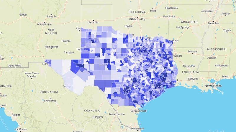
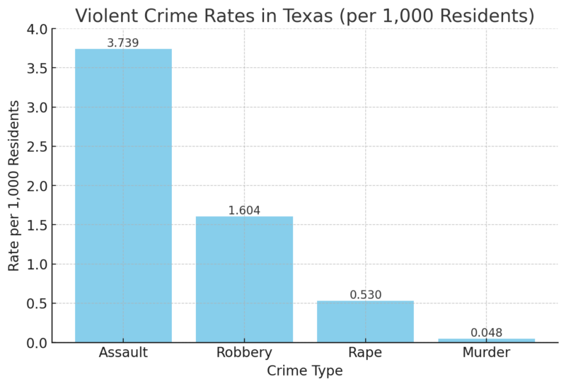
Texas experiences varying crime rates across its regions, with an average violent crime rate of 5.921 per 1,000 residents, resulting in an overall C- grade for violent crime, indicating slightly higher rates than the national average.
Property crime rates also contribute to Texas’s C grade for overall crime safety according to crimegrade.
Crime Grades and Frequency
Crime Type
Grade
Rate per 1,000 Residents
Violent Crime
C-
5.921
Property Crime
C
N/A
Other Crime
C
N/A
- Crime Frequency: A crime occurs every 21 seconds in Texas.
- Home Security Impact: Homes without security systems face a 300% higher risk of burglary.
Violent Crime Breakdown
Regional Safety Insights
- Northeast Texas: Known as the safest area, residents face a lower violent crime risk (1 in 303).
- Western Texas: Higher crime areas, with a 1 in 42 chance of encountering violent crime.
References:
- World Population Review – Texas Overview
- U.S. Census Bureau – Texas Census Data
- Crime Grade – Texas Crime Rates
Related Posts:
- Map of Pennsylvania - Cities, Geography, Counties &…
- Map of California - Cities, Geography, Counties &…
- Map of Colorado - Cities, Geography, Counties & Stats (2025)
- Map of Massachusetts - Geography, Cities, Counties &…
- Map of Alaska - Cities, Geography, Counties & Stats (2025)
- Map of Georgia - Cities, Geography, Counties & Stats (2025)


