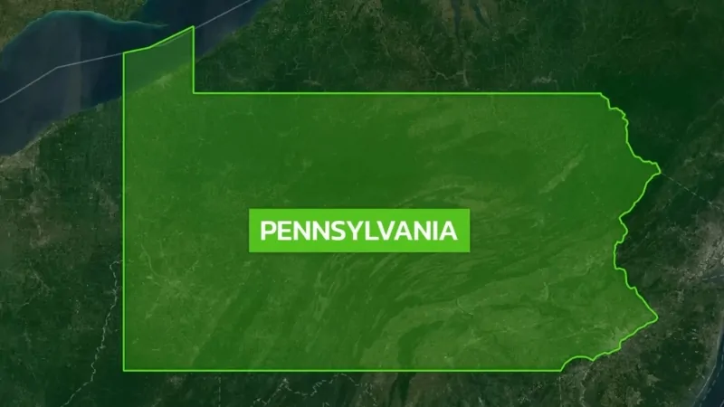
Pennsylvania, officially known as the Commonwealth of Pennsylvania, is a Mid-Atlantic state in the northeastern United States.
While landlocked, it does have a short 43-mile shoreline along Lake Erie.
Pennsylvania shares borders with New York to the north and northeast, with the Delaware River forming parts of its eastern boundary alongside New York and New Jersey.
To the south, it borders West Virginia, Maryland, and Delaware, and to the west, it meets Ohio.
In 1682, William Penn, an English real estate entrepreneur, was granted control of the area, giving him rights and privileges over the land—except the power to declare war.
Pennsylvania went on to become one of the 13 original colonies that ultimately broke away from British rule to form the United States.
On December 12, 1787, it became the second state to ratify the U.S. Constitution, just after Delaware.
Pennsylvania had aimed to be the first to ratify the Constitution, hoping this might secure it as the seat of the national government.
Philadelphia’s Pennsylvania State House, known today as Independence Hall, was a pivotal location for the American government during both the Revolutionary War and the early years of the new nation.
| Aspect | Facts |
|---|---|
| Also Known As | Keystone State, Commonwealth of Pennsylvania |
| State Nickname | Keystone State |
| State Motto | “Virtue, Liberty, and Independence” |
| State Bird | Ruffed Grouse |
| State Flower | Mountain Laurel |
| State Song | “Pennsylvania” |
| Capital | Harrisburg |
| Population | 12,951,300 |
| Largest City and County | Philadelphia, Philadelphia County |
| Date of Admission | December 12, 1787 |
| State Size | 46,055 square miles (119,282 km²) |
| Geographic Features | Appalachian, Allegheny, and Pocono Mountains; Delaware and Susquehanna Rivers |
| Borders | New York, New Jersey, Delaware, Maryland, West Virginia, Ohio; Lake Erie (51-mile shoreline) |
| Climate | Humid continental; humid subtropical in the southeast |
| Area (Water) | 1,239 sq mi (3,208 km²), 2.7% of the total |
| Notable Sites | Independence Hall, Liberty Bell, Gettysburg Battlefield |
| Electoral Votes | 19 |
| Time Zone | Eastern (GMT − 5 hours) |
Pennsylvania State Map and Satelite View
Pennsylvania, officially the Commonwealth of Pennsylvania, is a diverse U.S. state spanning the Mid-Atlantic, Northeastern, Appalachian, and Great Lakes regions.
It borders Delaware, Maryland, West Virginia, Ohio, New York, and New Jersey, with a northern shoreline along Lake Erie.
Founded in 1681 by William Penn as a haven of religious and political tolerance, it played a key role in the American Revolution, hosting the Continental Congresses in Philadelphia, where the Declaration of Independence was signed.
Pennsylvania became the second state to ratify the U.S. Constitution in 1787.
Geographically, it features the Appalachian Mountains, large forests, and Lake Erie shoreline.
Today, it’s the fifth-most populous state with 12,951,300 people according to World Population Review, with major cities including Philadelphia, Pittsburgh, Allentown, and Erie.
The state is divided into 67 counties.
Geography Map of State
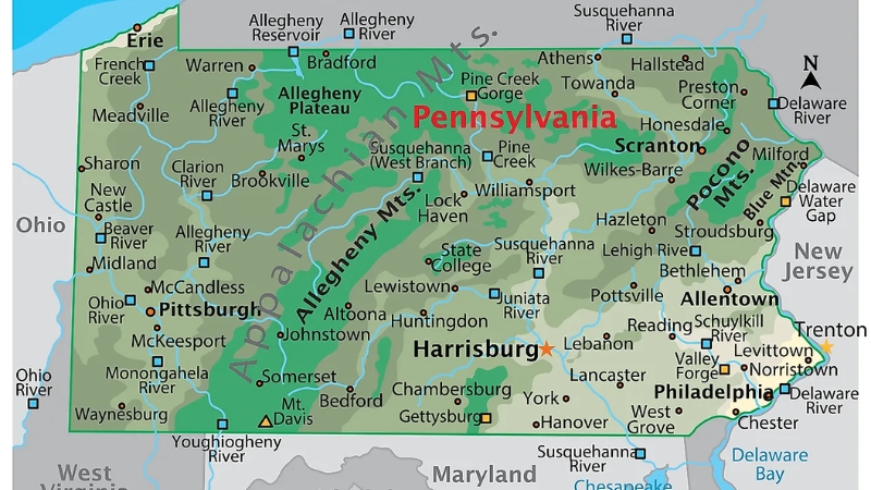
Pennsylvania covers 46,055 square miles, making it the 33rd-largest state in the U.S. It stretches 170 miles north to south and 283 miles east to west, with 44,817 square miles of land and about 1,239 square miles of inland waters, including portions of Lake Erie.
It has a coastline of 51 miles along Lake Erie and 57 miles along the Delaware Estuary, though it is the only original colony that does not touch the Atlantic Ocean.
Pennsylvania’s borders are defined by the Mason-Dixon line to the south, the Delaware River to the east, and Lake Erie to the northwest.
Regions and Climate
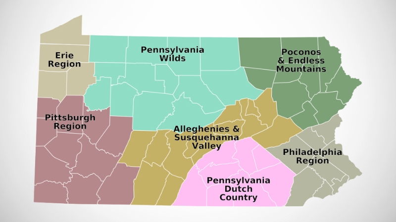
The state is divided into five major geographic regions: the Allegheny Plateau, Ridge and Valley, Atlantic Coastal Plain, Piedmont, and Erie Plain.
Pennsylvania experiences diverse climates due to its topography, with most of the state having a humid continental climate characterized by cold winters and humid summers.
The southeast, including Philadelphia, has a humid subtropical climate.
Western Pennsylvania, near Lake Erie, can receive over 100 inches of snow annually, and tornadoes are also possible, with 30 recorded in 2011.
Rivers and Lakes
In total, Pennsylvania has 46,055 square miles of land and inland waters, with a diverse system of rivers feeding major watersheds, including those of the Delaware, Chesapeake, and Ohio rivers, contributing significantly to both ecological diversity and the state’s economy.
Three main river systems traverse Pennsylvania. The Delaware River in the east is joined by the Lehigh and Schuylkill rivers.
The Susquehanna River, flowing through central Pennsylvania, is the largest and empties into the Chesapeake Bay.
In the west, the Ohio River begins at Pittsburgh, formed by the Allegheny and Monongahela rivers, and flows toward the Mississippi River.
Additionally, smaller waterways drain into Lake Erie and the Potomac River.
With the Allegheny and Pocono Mountains, scenic countryside, and numerous lakes, Pennsylvania is a paradise for outdoor enthusiasts.
The state boasts over 2,500 lakes, offering perfect spots for boating, swimming, fishing, kayaking, and relaxing on the shores.
Top 10 Lakes in Pennsylvania
Rank
Lake
1
Lake Erie
2
Raystown Lake
3
Lake Wallenpaupack
4
Pymatuning Lake
5
Blue Marsh Lake
6
Nockamixon Lake
7
Lake Arthur
8
Conneaut Lake
9
Shawnee Lake
10
Greenwood Lake
National Parks
National Park
Location
Type
Delaware Water Gap National Recreation Area
Bushkill, PA
National Recreation Area
Gettysburg National Military Park
Gettysburg, PA
National Military Park
Independence National Historical Park
Philadelphia, PA
National Historical Park
Valley Forge National Historical Park
Valley Forge, PA
National Historical Park
Allegheny Portage Railroad National Historic Site
Gallitzin, PA
National Historic Site
Edgar Allan Poe National Historic Site
Philadelphia, PA
National Historic Site
Eisenhower National Historic Site
Gettysburg, PA
National Historic Site
Friendship Hill National Historic Site
Point Marion, PA
National Historic Site
Gloria Dei Church National Historic Site
Philadelphia, PA
National Historic Site
Hopewell Furnace National Historic Site
Elverson, PA
National Historic Site
Johnstown Flood National Memorial
South Fork, PA
National Memorial
Steamtown National Historic Site
Scranton, PA
National Historic Site
Thaddeus Kosciuszko National Memorial
Philadelphia, PA
National Memorial
Fort Necessity National Battlefield
Farmington, PA
National Battlefield
Flight 93 National Memorial
Shanksville, PA
National Memorial
The state is home to 15 national parks, including historic sites, memorials, a battlefield, and recreational areas, each illustrating Pennsylvania’s rich cultural and natural heritage.
These sites encompass various types, such as National Historic Sites, National Memorials, a National Military Park, and a National Recreation Area, highlighting the state’s importance in U.S. history.
Many parks commemorate pivotal moments. Gettysburg National Military Park preserves the site of the Civil War’s Battle of Gettysburg, marking a crucial turning point.
Independence National Historical Park in Philadelphia celebrates the birthplace of American independence, where the Declaration of Independence and the U.S. Constitution were signed.
The Flight 93 National Memorial in Shanksville honors the courage of the passengers and crew who acted heroically on September 11, 2001.
Pennsylvania’s national parks also emphasize natural beauty.
The Delaware Water Gap National Recreation Area offers 40 miles of riverfront along the Delaware River, drawing millions of visitors for hiking, fishing, and scenic vistas.
Valley Forge National Historical Park, with 3,500 acres of meadows and woodlands, commemorates the endurance of the Continental Army during the winter of 1777-78.
Forests and Wildlife
At the time of European settlement in 1682, Pennsylvania was entirely forested.
Today, nearly half of the state is covered by forests, with species ranging from beech, maple, and birch in the north to oak and hickory in the south.
Pennsylvania is a prime hunting destination, with game such as rabbits, pheasants, squirrels, and large populations of deer and black bears.
Its rivers and streams, stocked annually with trout and other fish, also make it popular for fishing.
Population Heat Map
Pennsylvania, while relatively small in area, has a dense population typical of many eastern U.S. states.
According to the 2020 census, the state had 13,002,700 residents. Pennsylvania ranks as the 9th most densely populated state, with about 283.9 people per square mile.
A significant portion of the population is concentrated in Philadelphia and its surrounding areas, with Philadelphia alone home to approximately 1.56 million residents.
Other populous cities include Pittsburgh with 304,391 people, Allentown with 120,207, Erie with 99,475, and Reading with 87,879.
Among the counties, Philadelphia County has the largest population at 1,580,863, followed by Allegheny County with 1,223,048.
The median age in Pennsylvania is around 40.6 years, with a gender distribution of 51.1% female and 48.9% male.
Regarding religious affiliation, 73% of Pennsylvanians identify with Christian faiths, 6% with non-Christian religions, and 21% are unaffiliated.
Pennsylvania, one of the original 13 colonies, reached its present boundaries in 1792 with the acquisition of the Erie Triangle in the northwest. The state’s 1790 census covered all but this area.
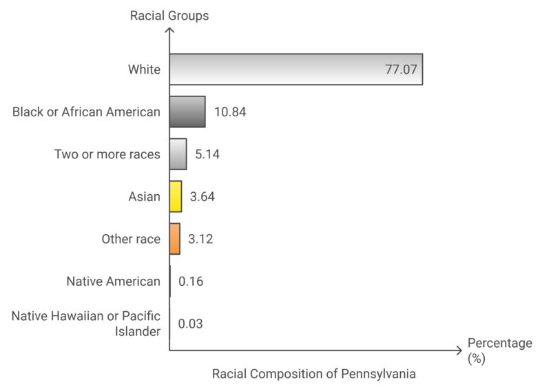
In terms of demographics, the latest ACS data reveals that Pennsylvania’s racial composition is:
Major Cities and Municipalities
Pennsylvania’s three largest cities are Philadelphia, Pittsburgh, and Allentown.
Other key cities include Reading, Erie, and Scranton, along with regions like the Lehigh Valley, which includes Allentown, Bethlehem, and Easton. Harrisburg, the state capital, lies on the Susquehanna River in east-central Pennsylvania.
Rank
City/Township
2025 Population
2023 Population
Population Density (per sq mi)
Area (sq mi)
Population Change (%)
Type
1
Philadelphia
1,533,828
1,566,836
11,416
134.4
-1.08%
City
2
Pittsburgh
303,413
302,799
5,479
55.4
0.05%
City
3
Allentown
124,597
125,088
7,094
17.6
-0.23%
City
4
Reading
94,878
94,847
9,639
9.8
-0.03%
City
5
Erie
92,371
93,595
4,828
19.1
-0.63%
City
6
Upper Darby township
84,894
84,892
10,849
7.8
0%
Township
7
Bethlehem
79,167
77,686
4,142
19.1
1.11%
City
8
Scranton
75,682
75,868
2,990
25.3
-0.16%
City
9
Lower Merion township
64,115
64,199
2,715
23.6
-0.07%
Township
10
Bensalem township
62,931
62,669
3,168
19.9
0.21%
Township
Counties Population
County
Population
Population Change (%)
Area (sq mi)
Density (people per sq mi)
Philadelphia County
1,534,248
-4.15%
52
11,450
Allegheny County
1,217,045
-2.6%
282
1,667
Montgomery County
872,440
1.8%
186
1,806
Bucks County
646,411
0.04%
233
1,070
Delaware County
577,567
0.21%
71
3,139
Lancaster County
560,518
1.39%
364
594
Chester County
552,930
3.38%
290
736
York County
468,231
2.52%
349
518
Berks County
434,069
1.26%
330
507
Lehigh County
379,234
1.26%
133
1,099
Westmoreland County
350,328
-1.13%
397
341
Luzerne County
328,280
0.94%
344
369
Northampton County
320,282
2.4%
143
866
Dauphin County
289,781
1.07%
203
552
Cumberland County
272,944
4.87%
210
501
Erie County
266,302
-1.58%
308
333
Lackawanna County
216,496
0.44%
177
472
Washington County
210,524
0.52%
331
246
Butler County
199,458
2.77%
305
253
Beaver County
165,525
-1.4%
168
381
Monroe County
164,655
-2.17%
235
271
Franklin County
158,757
1.8%
298
206
Centre County
158,057
0.05%
427
143
Lebanon County
144,602
0.92%
140
399
Schuylkill County
144,384
0.99%
301
185
Cambria County
129,907
-2.48%
266
189
Fayette County
122,462
-4.76%
305
155
Blair County
119,812
-2.33%
203
228
Lycoming County
112,414
-1.5%
474
91
Mercer County
107,869
-2.43%
260
160
Adams County
107,537
3.6%
200
207
Northumberland County
90,117
-1.56%
177
197
Lawrence County
84,132
-2.14%
138
236
Indiana County
83,124
-0.03%
319
101
Crawford County
81,597
-2.64%
391
81
Clearfield County
76,356
-5.07%
442
67
Somerset County
71,765
-3.05%
415
67
Columbia County
65,589
1.4%
186
136
Carbon County
65,423
1.04%
147
172
Armstrong County
63,444
-3.09%
252
97
Pike County
61,918
5.71%
210
114
Bradford County
59,536
-0.72%
443
52
Wayne County
51,440
0.56%
280
71
Venango County
49,128
-2.46%
260
73
Bedford County
47,279
-0.61%
391
47
Perry County
46,053
0.5%
213
84
Mifflin County
45,860
-0.6%
159
112
Huntingdon County
43,731
-0.72%
338
50
Jefferson County
43,493
-2.23%
252
67
Union County
41,394
-2.94%
122
131
Tioga County
40,713
-0.76%
438
36
Snyder County
39,928
0.49%
127
121
McKean County
39,219
-2.92%
378
40
Susquehanna County
38,079
-0.7%
318
46
Clinton County
37,438
0.18%
344
42
Warren County
37,326
-3.08%
341
42
Clarion County
36,713
-1.31%
232
61
Greene County
34,185
-4.69%
222
59
Elk County
29,929
-3.29%
319
36
Wyoming County
25,780
-0.97%
153
65
Juniata County
23,205
-1.19%
151
59
Montour County
17,666
-2.56%
50
136
Potter County
15,792
-3.61%
417
15
Fulton County
14,382
-1.35%
169
33
Forest County
6,295
-9.53%
165
15
Sullivan County
5,823
-0.09%
174
13
Cameron County
4,354
-3.82%
153
11
Pennsylvania has a total of 67 counties, two of which have populations exceeding one million.
Philadelphia County, which shares its boundaries with the city of Philadelphia, has 1,574,765 residents, making it the second smallest county in the state by land area despite its large population. Allegheny County follows with 1,227,553 residents according to World Population Review.
As of 2018, both counties have seen population growth since the last census, with Philadelphia County increasing by 3.04% and Allegheny County by a modest 0.30%.
Philadelphia, Pennsylvania
Philadelphia County
Population: 5,649,300
Photos from Google Places API
Link: https://t.co/kl8MNopY0Z pic.twitter.com/xYcaFHzFDX— New town every hour (@TownsUsa) December 8, 2023
Airports in Pennsylvania
Airport Name
Location
IATA Code
Philadelphia International Airport
Philadelphia
PHL
Pittsburgh International Airport
Pittsburgh
PIT
Harrisburg International Airport
Harrisburg
MDT
Lehigh Valley International Airport
Allentown
ABE
Wilkes-Barre/Scranton International Airport
Avoca
AVP
Erie International Airport
Erie
ERI
University Park Airport
State College
SCE
Arnold Palmer Regional Airport
Latrobe
LBE
Lancaster Airport
Lancaster
LNS
Williamsport Regional Airport
Williamsport
IPT
Altoona–Blair County Airport
Martinsburg
AOO
Bradford Regional Airport
Lewis Run
BFD
John Murtha Johnstown–Cambria County Airport
Johnstown
JST
Dubois Regional Airport
DuBois
DUJ
Venango Regional Airport
Franklin
FKL
Reading Regional Airport
Reading
RDG
Capital City Airport
Harrisburg
CXY
Northeast Philadelphia Airport
Philadelphia
PNE
Allegheny County Airport
Pittsburgh
AGC
Chester County G. O. Carlson Airport
Coatesville
CTH
Beaver County Airport
Beaver Falls
BFP
Doylestown Airport
Doylestown
DYL
New Castle Municipal Airport
New Castle
UCP
Butler County Airport
Butler
BTP
Pocono Mountains Municipal Airport
Mount Pocono
MPO
Washington County Airport
Washington
WSG
Hazleton Regional Airport
Hazleton
HZL
Bedford County Airport
Bedford
HMZ
Mifflin County Airport
Reedsville
RED
Somerset County Airport
Somerset
2G9
Clearfield–Lawrence Airport
Clearfield
FIG
Indiana County–Jimmy Stewart Field
Indiana
IDI
Mid-State Airport
Philipsburg
PSB
Port Meadville Airport
Meadville
MEJ
Schuylkill County Airport
Pottsville
ZER
Clarion County Airport
Clarion
AXQ
St. Marys Municipal Airport
St. Marys
STQ
Punxsutawney Municipal Airport
Punxsutawney
N35
Bloomsburg Municipal Airport
Bloomsburg
N13
Bradford County Airport
Towanda
N27
Corry–Lawrence Airport
Corry
8G2
Ebensburg Airport
Ebensburg
9G8
Grove City Airport
Grove City
29D
Jake Arner Memorial Airport
Lehighton
22N
Joseph A. Hardy Connellsville Airport
Connellsville
VVS
New Garden Airport
Toughkenamon
N57
Pottstown Municipal Airport
Pottstown
N47
Quakertown Airport
Quakertown
UKT
Rostraver Airport
Monongahela
FWQ
Wings Field
Blue Bell
BBX
Heritage Field Airport
Pottstown
PTW
Brandywine Airport
West Chester
OQN
Pittsburgh–Butler Regional Airport
Butler
BTP
Heritage Creek Airstrip
Mount Pleasant
7G4
Beaver County Airport
Beaver Falls
BVI
Allegheny County Airport
West Mifflin
AGC
Capital City Airport
New Cumberland
CXY
Chester County G. O. Carlson Airport
Coatesville
MQS
Doylestown Airport
Doylestown
DYL
New Castle Municipal Airport
New Castle
UCP
Pittsburgh–Butler Regional Airport
Butler
BTP
Pocono Mountains Municipal Airport
Mount Pocono
MPO
Washington County Airport
Washington
AFJ
Hazleton Regional Airport
Hazleton
HZL
Bedford County Airport
Bedford
HMZ
Mifflin County Airport
Reedsville
RVL
Somerset County Airport
Somerset
2G9
Clearfield–Lawrence Airport
Clearfield
FIG
Indiana County–Jimmy Stewart Field
Indiana
IDI
Mid-State Airport
Philipsburg
PSB
Port Meadville Airport
Meadville
GKJ
Schuylkill County Airport
Pottsville
ZER
Clarion County Airport
Clarion
AXQ
St. Marys Municipal Airport
St. Marys
OYM
Punxsutawney Municipal Airport
Punxsutawney
N35
Bloomsburg Municipal Airport
Bloomsburg
N13
Bradford County Airport
Towanda
N27
Corry–Lawrence Airport
Corry
8G2
Ebensburg Airport
Ebensburg
9G8
Grove City Airport
Grove City
29D
Jake Arner Memorial Airport
Lehighton
22N
Joseph A. Hardy Connellsville Airport
Connellsville
VVS
New Garden Airport
Toughkenamon
N57
Pottstown Municipal Airport
Pottstown
N47
Quakertown Airport
Quakertown
UKT
Rostraver Airport
Monongahela
FWQ
Wings Field
Blue Bell
LOM
Heritage Field Airport
Pottstown
PTW
Brandywine Airport
West Chester
OQN
Pittsburgh–Butler Regional Airport
Butler
BTP
Heritage Creek Airstrip
Mount Pleasant
7G4
Beaver County Airport
Beaver Falls
BVI
Allegheny County Airport
West Mifflin
AGC
Capital City Airport
New Cumberland
CXY
Pennsylvania has a robust network of over 100 public-use airports, ranging from major international hubs to small regional and municipal airports.
The state’s two largest airports, Philadelphia International Airport (PHL) and Pittsburgh International Airport (PIT), serve as primary gateways, handling a high volume of domestic and international flights.
Together, they facilitate the bulk of the state’s air traffic, supporting both passenger travel and cargo transport.
In addition to these primary airports, Pennsylvania has several mid-sized airports, including Harrisburg International (MDT) and Lehigh Valley International (ABE), which serve regional travel needs.
Smaller airports like Wilkes-Barre/Scranton International (AVP) and Erie International (ERI) provide vital connections to surrounding states and communities.
Furthermore, there are a number of municipal and general aviation airports, such as Lancaster Airport (LNS) and Altoona–Blair County Airport (AOO), that support private aviation, training, and local businesses.
References:
- World Population Review – Population of Pennsylvania
- US Census Bureau – Pennsylvania Population
- NeilsBerg – Pennsylvania Population by Race
Related Posts:
- Map of Florida - Cities, Geography, Counties & Stats (2025)
- Map of Texas - Cities, Geography, Counties & Stats (2025)
- Map of State of New York - Cities, Geography,…
- Map of Georgia - Cities, Geography, Counties & Stats (2025)
- Map of California - Cities, Geography, Counties &…
- Map of Colorado - Cities, Geography, Counties & Stats (2025)


