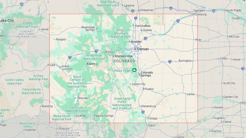
Colorado, one of the 50 states in the U.S., is a landlocked state located in the heart of the country.
Named after the Colorado River, it is unique in that its borders are formed entirely by straight lines of latitude and longitude, a distinction it shares with Wyoming and Utah.
The state is bordered by Wyoming and Nebraska to the north, Kansas to the east, Oklahoma and New Mexico to the south, and Utah to the west.
Part of Colorado’s territory was acquired through the Louisiana Purchase in 1803, while the rest was ceded by Mexico in 1848.
On August 1, 1876, Colorado became the 38th state to join the Union.
Table of Contents
ToggleColorado State Map and Satelite View
A landlocked state in the Western U.S., is known for its diverse landscapes, including the Southern Rocky Mountains, the Colorado Plateau, and the Great Plains.
It covers 104,185 square miles, making it the 8th largest state, and had a population of about 5.91 million as of 2025.
Colorado’s capital and largest city is Denver, and residents are called Coloradans.
Historically inhabited by Native Americans for over 13,500 years, the area became part of the U.S. through the Louisiana Purchase (1803) and the Treaty of Guadalupe Hidalgo (1848).
The Pike’s Peak Gold Rush (1858–1862) spurred settlement, and it became the 38th state in 1876.
Today, the state’s economy relies on government, mining, agriculture, tourism, and manufacturing, while climate change poses challenges to key sectors like agriculture and forestry.
Geography Map
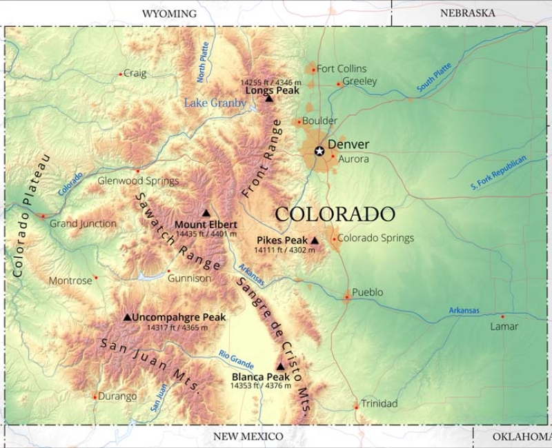
Colorado features a diverse landscape that includes alpine mountains, high plains, vast deserts with dunes, and deep canyons.
Established as a territory in 1861, its borders are uniquely defined by straight lines of latitude and longitude, stretching from 37°N to 41°N and 102°02′48″W to 109°02′48″W.
The Four Corners Monument in the southwest marks the only point in the U.S. where four states meet—Colorado, New Mexico, Arizona, and Utah.
Plains
The Eastern Plains of Colorado, part of the High Plains, make up nearly half the state.
Elevations range from 3,350 to 7,500 feet, with prairies, canyons, and forests characterizing the terrain.
This semi-arid region receives 15–25 inches of annual precipitation and is primarily farmland, producing crops like corn, wheat, and hay.
Livestock farming, especially cattle and hogs, is significant, though heavy irrigation has led to declining underground water reserves.
Front Range
The Front Range Urban Corridor, located along the eastern Rockies, is home to about 70% of Colorado’s population.
Cities such as Denver, Boulder, Colorado Springs, and Pueblo anchor this region, which benefits from the Rockies’ protection against Pacific storms.
The Front Range is Colorado’s economic and cultural hub, while western cities like Grand Junction and Durango form population centers on the state’s Western Slope.
Mountains
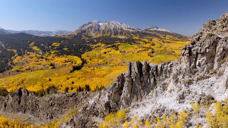
Colorado’s Rocky Mountains rise west of the Great Plains, with notable peaks such as Mount Elbert (14,440 feet) and Pikes Peak.
The state boasts 58 fourteeners (peaks over 14,000 feet), the most in North America, and a diverse landscape of alpine vegetation and coniferous forests up to the tree line.
This region is a crucial water source, with snowmelt feeding rivers like the Mississippi and Rio Grande.
Highest and Lowest Points
Mount Elbert, at 14,440 feet, is the highest point in Colorado and the Rocky Mountains of North America.
The state’s lowest point, where the Arikaree River flows into Kansas, is at 3,317 feet—higher than the highest points of 18 U.S. states and Washington, D.C.
Remarkably, all of Colorado lies above 1,000 meters in elevation, the only state with this distinction.
Continental Divide
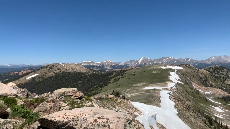
The Continental Divide of the Americas runs along the crest of Colorado’s Rocky Mountains, separating watersheds that flow to the Pacific Ocean from those draining into the Gulf of Mexico.
Grays Peak, at 14,278 feet, is the highest point on the Divide in North America.
To the west lies Colorado’s Western Slope, where rivers like the Colorado and Green Rivers flow southwest toward the Gulf of California.
Within the Rockies, several high basins known as “parks” are prominent:
- North Park lies east of the Divide and is drained by the North Platte River, which flows into Wyoming and Nebraska.
- Middle Park, west of the Divide, is drained by the Colorado River.
- South Park, situated along the South Platte River’s headwaters, contributes to Colorado’s distinct regional topography.
South Central Region
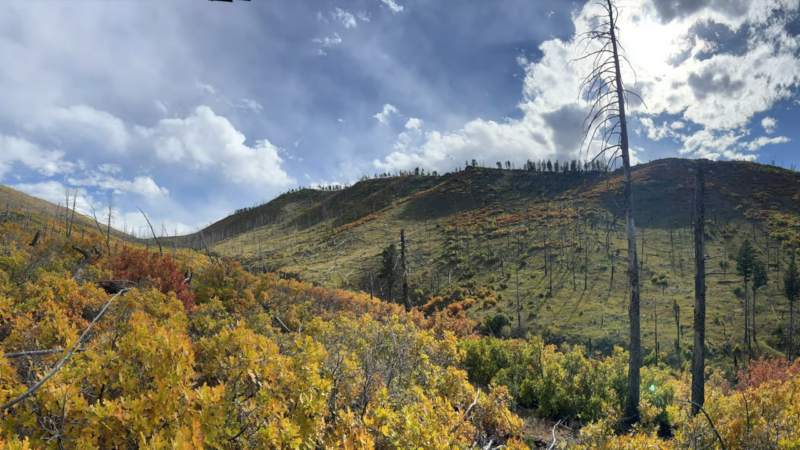
The San Luis Valley, located in south-central Colorado, is a high desert basin surrounded by the Sangre de Cristo Mountains to the east and the San Juan Mountains to the west.
It is the source of the Rio Grande, which flows southward into New Mexico, Texas, and Mexico.
The valley contains the San Luis Closed Basin, an endorheic basin that created the iconic Great Sand Dunes.
To the east lies the Wet Mountain Valley, with the entire region situated along the Rio Grande Rift, a significant geological formation.
Western Slope
The Western Slope encompasses Colorado’s western Rocky Mountain slopes and stretches to the state’s western border.
It features diverse terrains, including alpine forests, arid deserts, and deep canyons.
Notable attractions include the Colorado National Monument, Dinosaur National Monument, and ski resorts such as Aspen, Vail, and Telluride.
Wow, absolutely stunning. The Colorado National Monument is spectacular.
P: @csdekalbphotos #sharegj pic.twitter.com/T0eF0oBXru
— Visit Grand Junction (@VisitGJ) October 26, 2024
This less populous region is also home to Grand Junction, its largest city, located at the confluence of the Colorado and Gunnison Rivers.
The Colorado River and its tributaries, including the Gunnison and San Juan Rivers, dominate the area, flowing through iconic landscapes like Glenwood Canyon and the Grand Valley.
Other highlights include the Grand Mesa, the rugged San Juan Mountains, and portions of the Colorado Plateau.
The Western Slope also hosts several institutions of higher education, including Colorado Mesa University and Western Colorado University.
Rivers and Lakes
Major Rivers
Colorado River
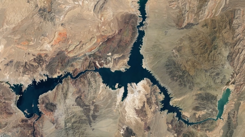
- Length: 1,450 miles (total), about 240 miles in Colorado.
- Origin: Rocky Mountain National Park.
- Flow: Southwest through the state into Utah, carving iconic canyons like Glenwood Canyon.
- Significance: Supplies water to seven U.S. states and Mexico.
Rio Grande
- Length: 1,896 miles (total), about 175 miles in Colorado.
- Origin: San Luis Valley.
- Flow: Southward into New Mexico and Texas.
- Significance: Supports agriculture and drinking water in three states and Mexico.
Arkansas River
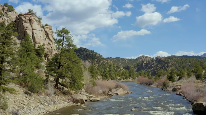
- Length: 1,469 miles (total), about 300 miles in Colorado.
- Origin: Near Leadville in the Sawatch Range.
- Flow: Southeast through Pueblo and into Kansas.
- Significance: Popular for rafting and irrigation.
South Platte River
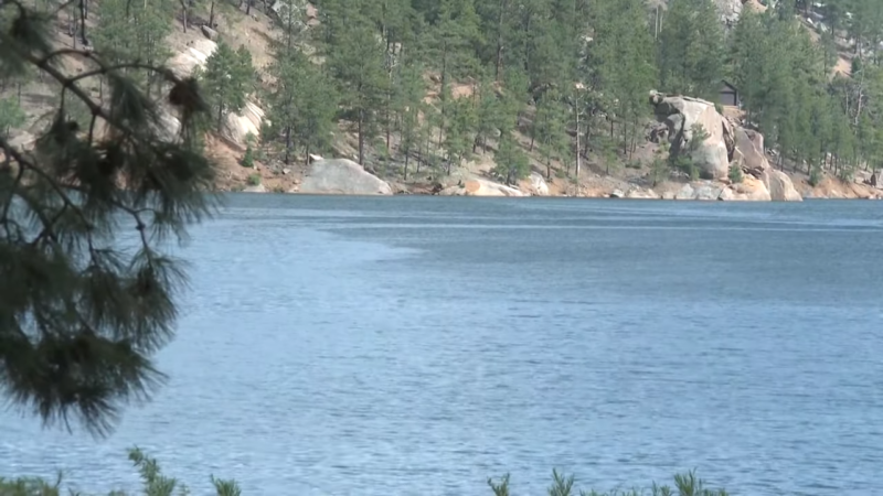
- Length: 439 miles in Colorado (total 900 miles).
- Origin: the Rocky Mountains near Fairplay.
- Flow: Northeast through Denver into Nebraska.
- Significance: Key water source for Denver and surrounding areas.
Gunnison River
View this post on Instagram
A post shared by Cassandra | Adventuring Holistic Virtual Assistant (@cloveliness)
- Length: 164 miles in Colorado.
- Origin: Confluence of East and Taylor Rivers near Almont.
- Flow: Southwest to join the Colorado River.
- Significance: Known for carving the Black Canyon of the Gunnison.
Yampa River
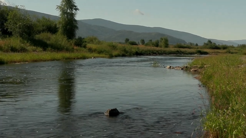
- Length: 250 miles in Colorado.
- Origin: Flows from the Flat Tops near Steamboat Springs.
- Flow: Joins the Green River in Utah.
- Significance: Important for recreation and wildlife in northwestern Colorado.
Major Lakes and Reservoirs
Grand Lake
- Size: 507 acres; 265 feet deep.
- Location: Near Rocky Mountain National Park.
- Significance: Largest natural lake in Colorado, scenic for fishing and boating.
Blue Mesa Reservoir
- Size: 9,180 acres; 20 miles long.
- Location: Gunnison River, Curecanti National Recreation Area.
- Significance: Largest reservoir in Colorado, popular for fishing and boating.
Horsetooth Reservoir
- Size: 1,900 acres; 6.5 miles long.
- Location: Near Fort Collins.
- Significance: Recreational hotspot for water sports and hiking.
Lake Dillon (Dillon Reservoir)
- Size: 3,233 acres; 79 miles of shoreline.
- Location: Near Breckenridge and Keystone.
- Significance: Supplies water to Denver; surrounded by mountain views.
Pueblo Reservoir
- Size: 4,500 acres; 60 miles of shoreline.
- Location: Arkansas River near Pueblo.
- Significance: Key for irrigation and recreation in southeastern Colorado.
Climate of Colorado
Colorado’s climate is highly diverse, shaped by its mountains, high plains, and deserts, with significant local variations due to elevation.
The Eastern Plains experience a semi-arid climate with hot summers, cool nights, and cold, dry winters, while the Front Range benefits from Chinook winds that bring warmer winters.
The Western Slope features a mix of alpine and arid climates, with more moisture at higher elevations.
Extreme weather includes hailstorms, tornadoes, floods, and wildfires, driven by the state’s dry climate and frequent droughts.
Climate records show a highest temperature of 115°F (46.1°C) in 2019 and a lowest of -61°F (-51.7°C) in 1985.
Climate change is increasing the frequency of wildfires, droughts, and reduced water flow in rivers, affecting agriculture, forestry, and water availability.
Average Monthly Temperatures in Major Colorado Cities
City
Jan (°F)
Apr (°F)
Jul (°F)
Oct (°F)
Alamosa
34/-2
59/24
82/47
62/25
Colorado Springs
43/18
60/33
85/57
63/36
Denver
49/20
64/35
92/61
68/37
Grand Junction
38/17
65/38
93/63
66/40
Pueblo
47/14
67/34
93/59
69/34
Population Heat Map
The population of Colorado was estimated at 5,914,180 in 2025, based on the most recent Census projections.
The last official count during the 2010 Census recorded 5,029,196 residents, reflecting a 16.9% increase from 2000’s population of 4,301,262.
By 2015, the state’s population had grown to 5,456,574, marking an 8.5% rise since 2010.
With a yearly growth rate of 1.85% in 2016, Colorado became the second-fastest-growing state in the U.S.
Denver, Colorado’s largest city and capital, is home to over 700,000 residents.
Despite its size, the state’s rugged terrain, including the Rocky Mountains, limits population density to approximately 52 people per square mile (19.9 per square kilometer), ranking Colorado 37th in population density among U.S. states.
The state’s median age is 36.4 years, with the population divided nearly equally by gender (49.8% female and 50.1% male).
Religious affiliation in Colorado is as follows: 64% Christian, 5% non-Christian religions, and 29% unaffiliated.
Part of Colorado was acquired during the Louisiana Purchase (1803), but the area lacked organized government until 1850.
Colorado became a territory in 1861, drawing land from Kansas, Nebraska, New Mexico, and Utah territories, and achieved statehood on August 1, 1876.
The first census covering Colorado’s current boundaries was conducted in 1860.
Demographics and Racial Composition
According to the most recent data, Colorado’s racial composition is shown in the table below:
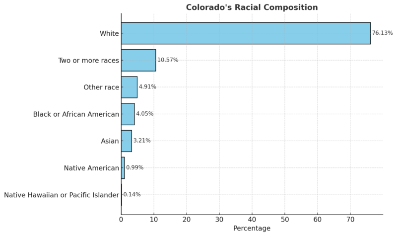
Approximately 10% of Colorado’s population consists of immigrants, who contribute over 11% of the workforce.
Latinos make up a significant portion of the state’s demographics, especially in cities like Colorado Springs, Metro Denver, Pueblo, and Greeley.
Colorado has the fifth-largest Mexican-American population in the U.S., with 34.9% of Latinos under the age of 18, surpassing other racial groups in this age bracket.
Largest Cities in Colorado
Rank
City
Population 2023
Population 2022
Population Density (per sq. mile)
Area (sq. miles)
Growth Rate
Type
1
Denver
716,234
713,453
4,679
153.1
-0.05%
City
2
Colorado Springs
491,441
486,304
2,434
201.9
0.57%
City
3
Aurora
397,811
393,794
2,440
163.0
0.70%
City
4
Fort Collins
170,507
170,114
2,979
57.2
0.08%
City
5
Lakewood
155,865
156,001
3,587
43.5
-0.06%
City
6
Thornton
145,834
143,247
3,995
36.5
0.63%
City
7
Arvada
120,437
121,430
3,090
39.0
-0.80%
City
8
Westminster
114,302
114,771
3,615
31.6
-0.50%
City
9
Greeley
113,721
109,245
2,300
49.4
0.99%
City
10
Pueblo
110,803
111,418
1,961
56.5
-0.25%
City
WPR notes that the most populous city, Denver, has a population of 716,234, though its growth rate has slightly declined.
Colorado Springs and Aurora are the second and third largest cities, with consistent growth rates of 0.57% and 0.70%, respectively.
Other cities like Greeley and Thornton are also experiencing steady growth, while cities like Arvada and Westminster show small declines in population.
Counties in Colorado
County
Population
Growth Rate
Area (sq. miles)
Density (per sq. mile)
El Paso
747,834
2.11%
821
352
Denver
719,701
0.29%
59
4,704
Arapahoe
655,853
0.09%
308
822
Jefferson
576,921
-1.06%
295
755
Adams
539,221
3.6%
450
462
Douglas
391,875
8.76%
325
466
Larimer
373,965
3.9%
1,000
144
Weld
368,618
11.21%
1,500
93
Boulder
326,323
-1.39%
280
449
Pueblo
169,372
0.61%
921
71
Mesa
160,831
3.09%
1,300
48
Broomfield
77,525
4.07%
13
2,349
Garfield
63,158
2.21%
1,100
21
La Plata
56,261
1.06%
652
33
Eagle
53,544
-3.8%
650
32
Fremont
51,020
4.38%
592
33
Montrose
44,505
3.94%
865
20
Delta
31,932
2.82%
441
28
Summit
30,294
-2.28%
235
50
Morgan
29,782
2.43%
494
23
Elbert
29,770
13.56%
714
16
Montezuma
26,595
2.73%
783
13
Routt
25,056
0.9%
912
11
Teller
24,374
-1.5%
215
44
Chaffee
20,969
7.62%
391
21
Logan
20,446
-3.6%
710
11
Park
18,313
5.14%
847
8
Otero
17,961
-3.77%
487
14
Gunnison
17,322
2.19%
1,300
5
Alamosa
16,723
2.11%
279
23
Pitkin
16,433
-5.31%
375
17
Grand
16,136
2.47%
713
9
Archuleta
14,389
7.19%
521
11
Las Animas
14,385
-0.72%
1,800
3
Moffat
13,449
1.36%
1,800
3
Prowers
11,629
-3.23%
632
7
Rio Grande
11,039
-4.35%
352
12
Yuma
9,829
-1.42%
913
4
Clear Creek
8,927
-4.96%
152
23
San Miguel
7,728
-4.05%
497
6
Conejos
7,455
0.05%
497
6
Lake
7,384
-0.32%
146
20
Huerfano
7,013
2.72%
614
4
Kit Carson
7,005
-0.81%
834
3
Saguache
6,749
5.63%
1,200
2
Rio Blanco
6,589
1.06%
1,200
2
Gilpin
5,966
2.51%
58
40
Bent
5,923
8.22%
584
4
Custer
5,731
21.34%
285
8
Crowley
5,645
-0.76%
304
7
Lincoln
5,450
-3.74%
1,000
2
Ouray
5,249
7.52%
209
10
Washington
4,863
1.04%
972
2
Phillips
4,504
-0.51%
266
7
Costilla
3,641
3.97%
474
3
Baca
3,253
-6.52%
986
1
Dolores
2,566
10.08%
412
2
Sedgwick
2,312
-3.22%
212
4
Cheyenne
1,723
-1.32%
686
1
Kiowa
1,334
-8.32%
682
1
Jackson
1,304
-5.44%
623
1
Mineral
957
9.5%
338
1
San Juan
798
12.24%
150
2
Hinsdale
759
-3.68%
431
1
Colorado’s most populous county in 2019 is Denver County, with a population of 704,621, reflecting a 16.81% growth since 2010 as per World Population Review notes.
Other counties with over 500,000 residents include El Paso, Arapahoe, Jefferson, and Adams, all showing significant growth.
San Juan County is the smallest, with just 715 people, and 26 counties in the state have populations under 10,000.
Broomfield County experienced the highest growth at 21.57%, while Kit Carson County had the steepest decline at -13.38%.
Major Airports
Airport Name
Location
IATA Code
Denver International Airport
Denver
DEN
Colorado Springs Airport
Colorado Springs
COS
Grand Junction Regional Airport
Grand Junction
GJT
Eagle County Regional Airport
Eagle/Vail
EGE
Pueblo Memorial Airport
Pueblo
PUB
Montrose Regional Airport
Montrose
MTJ
Aspen/Pitkin County Airport
Aspen
ASE
Durango-La Plata County Airport
Durango
DRO
Steamboat Springs Airport
Steamboat Springs
HDN
Vail/Eagle County Airport
Vail
EGE
Crime Map of Colorado
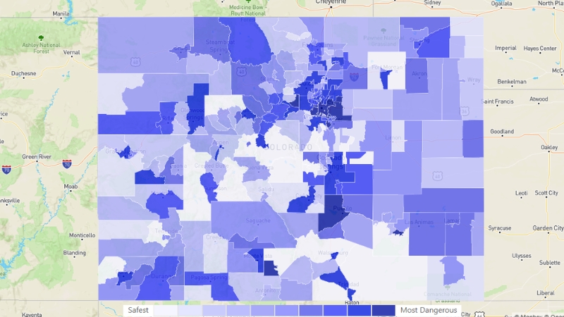
Colorado’s crime rates are categorized into two main types: violent crime and property crime.
In 2023, there were a total of 212,575 reported crimes in Colorado, with 28,759 violent crimes and 183,816 property crimes according to Neighborhood Scout.
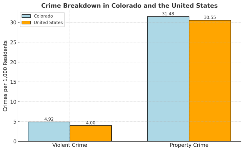
The overall crime rate in Colorado is 36.40 per 1,000 residents, with violent crime at 4.92 per 1,000 residents and property crime at 31.48 per 1,000 residents.
The chances of becoming a victim of a violent crime in Colorado are 1 in 203, while the likelihood of being a victim of a property crime is 1 in 32.
Crime Breakdown in Colorado and the United States
Violent Crime Breakdown in Colorado
| Crime Type | Colorado Total | Rate per 1,000 residents | United States Total | Rate per 1,000 residents |
|---|---|---|---|---|
| Murder | 375 | 0.06 | 21,156 | 0.06 |
| Rape | 3,700 | 0.63 | 133,294 | 0.40 |
| Robbery | 4,241 | 0.73 | 220,450 | 0.66 |
| Assault | 20,443 | 3.50 | 893,980 | 2.68 |
Related Posts:
- Map of the City of Denver, Colorado – Geography,…
- Map of Florida - Cities, Geography, Counties & Stats (2025)
- Map of Texas - Cities, Geography, Counties & Stats (2025)
- Map of State of New York - Cities, Geography,…
- Map of Georgia - Cities, Geography, Counties & Stats (2025)
- Map of Pennsylvania - Cities, Geography, Counties &…


