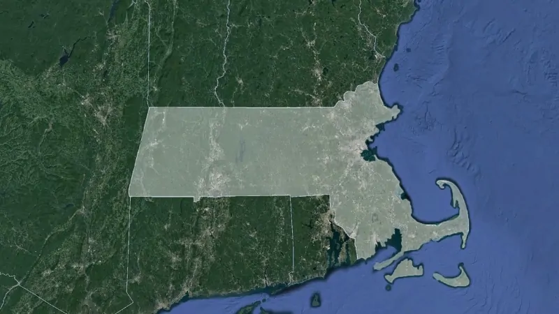
Massachusetts, officially the Commonwealth of Massachusetts, is a northeastern U.S. state and one of the six New England states.
It borders Vermont and New Hampshire to the north, Rhode Island and Connecticut to the south, New York to the west, and the Atlantic Ocean to the east.
Known as “The Bay State” and sometimes referred to as “The Spirit of America,” the state’s name originates from an Algonquian word meaning “at the big hill.”
Settled by the Mayflower Pilgrims in 1620, Massachusetts played a significant role in early American history.
The Plymouth Colony, recreated today at the Plimoth Plantation Living History Museum, was one of the first permanent English settlements in the country.
Table of Contents
ToggleMassachusetts State Map and Satelite View
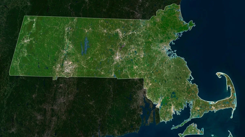
By the mid-18th century, Massachusetts had become a center of resistance against British rule and a driving force in the American Revolution.
Boston, the capital, is celebrated as “the birthplace of the American Revolution.”
Massachusetts was admitted to the Union on February 6, 1788, as the sixth state. Its rich history, coastal location, and contributions to American independence make it a cornerstone of the nation’s heritage.
Geography Map of State
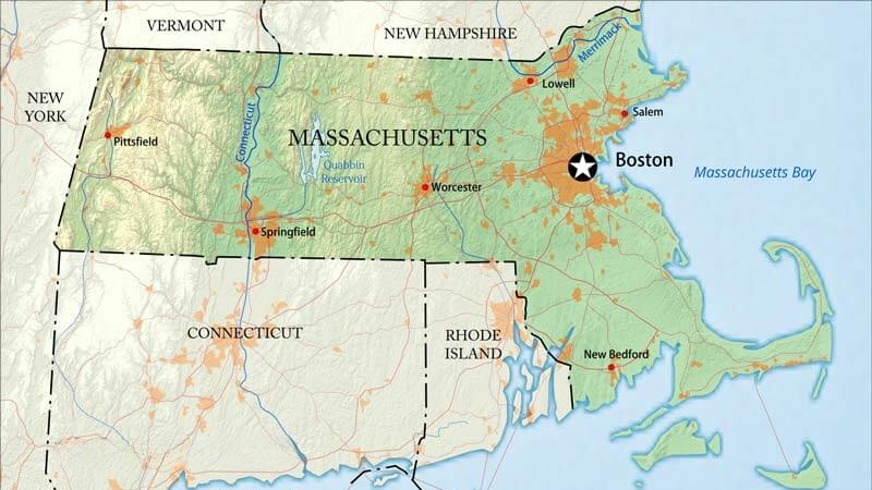
Massachusetts, the seventh-smallest state in the U.S., spans 10,555 square miles, with 25.7% of its area consisting of water. Its coastline, shaped by several large bays, earns it the nickname “the Bay State.”
The eastern region features a broad coastal plain and Cape Cod, while Central Massachusetts is hilly and rural.
The Connecticut River Valley lies further west, and the Berkshires, part of the Appalachian Mountains, form the state’s highest elevations in the west.
The state includes numerous national parks, trails, and conservation areas, such as the Cape Cod National Seashore and Boston Harbor Islands National Recreation Area.
Ecology
Massachusetts is largely covered by temperate deciduous forests, which have regenerated after past agricultural clearances.
Urban areas, like Greater Boston and Springfield, show significant human development, while rural regions support wildlife such as moose, black bears, and migratory waterfowl.
@centuoworld The Piping Plover is an endangered shorebird known for its delicate beauty and distinct, melodic call. Within just a few days of hatching, chicks like this one are highly mobile, exploring their sandy habitats for food. These tiny birds rely on their camouflage and quick movements to avoid predators. #pipingplover ♬ original sound – Centuo World
The state’s coasts and offshore islands are critical habitats for species like piping plovers and grey seals.
Marine wildlife includes endangered North Atlantic right whales, Atlantic cod, and harbor seals.
Massachusetts also faces challenges such as habitat loss and invasive species but has seen urbanized wildlife like peregrine falcons and coyotes adapt successfully.
Climate
Location
July (°F)
July (°C)
January (°F)
January (°C)
Boston
81 / 65
27 / 18
36 / 22
2 / −5
Worcester
79 / 61
26 / 16
31 / 17
0 / −8
Springfield
84 / 62
27 / 17
34 / 17
1 / −8
New Bedford
80 / 65
26 / 18
37 / 23
3 / −4
Quincy
80 / 61
26 / 16
33 / 18
1 / −7
Plymouth
80 / 61
27 / 16
38 / 20
3 / −6
Most of Massachusetts has a humid continental climate, with cold winters and warm summers. Southeastern coastal areas transition toward humid subtropical conditions.
Boston, representative of the state’s climate, experiences summer highs around 81°F (27°C) and winter highs near 35°F (2°C).
Precipitation is evenly distributed year-round, with frequent frost in winter.
The Northeast is warming faster than the global average, with significant increases in heavy precipitation events over recent decades.
This climate shift impacts ecosystems and human health, including rising cases of Lyme disease and expanding habitats for disease-carrying insects.
View this post on Instagram
A post shared by Massachusetts Energy and Environmental Affairs (@masseea)
Rivers and Lakes in Massachusetts
Name
Type
Length (Miles) / Area (Square Miles)
Significance
Merrimack River
River
117 miles (partial in MA)
Historical industrial hub; northeastern MA
Charles River
River
80 miles
Iconic for Boston and Cambridge; rowing events
Housatonic River
River
149 miles (partial in MA)
Scenic Berkshires region; recreational use
Deerfield River
River
76 miles (partial in MA)
Known for rafting and picturesque landscapes
Ipswich River
River
35 miles
Key for local water supply and wildlife habitat
Neponset River
River
30 miles
Historical significance; flows into Boston Harbor
Blackstone River
River
48 miles (partial in MA)
Central to the American Industrial Revolution
Lake Cochituate
Lake
3.8 square miles
Recreational activities; located in Natick
Wachusett Reservoir
Lake
6.5 square miles
Major water supply; surrounded by trails
Long Pond
Lake
1.71 square miles
Popular for fishing and boating in Lakeville
Largest River: The Connecticut River
The Connecticut River is the longest river in Massachusetts, stretching about 407 miles overall, with approximately 69 miles flowing through the state. It runs north to south through the fertile Connecticut River Valley, a region known for its agriculture and scenic beauty.
The river also supports diverse ecosystems and provides recreational opportunities such as boating and fishing.
Largest Lake: Quabbin Reservoir
The Quabbin Reservoir, where Boston gets its drinking water, is the largest inland body of water in Massachusetts and holds 412,000,000,000 gallons of water and its creation required the flooding, in 1938, of four towns: Dana, Enfield, Greenwich, and Prescott.
— Only In Boston (@OnlyInBOS) May 16, 2024
The Quabbin Reservoir, covering 38.6 square miles, is the largest lake in Massachusetts by surface area. It serves as a critical water supply for Boston and surrounding areas, providing clean drinking water to over 3 million people.
The reservoir is surrounded by protected lands, making it a haven for wildlife and a popular spot for hiking and birdwatching.
Environmental Issues
Climate change poses significant risks to Massachusetts, affecting agriculture, fisheries, forestry, and coastal infrastructure. By 2035, the Northeast is projected to warm by over 3.6°F (2°C) compared to preindustrial levels.
Increased precipitation during winter and spring leads to earlier snowmelt, drier summer soils, and more extreme weather events.
Boston alone could face $5 to $100 billion in damages from storms. Warmer temperatures disrupt wildlife patterns and increase health risks from diseases like Lyme and West Nile virus.
In response, the state aims to achieve net-zero emissions by 2050 and reduce greenhouse gas emissions by 85%.
Power Initiatives
Massachusetts promotes renewable energy and energy-efficient technologies through programs like Mass Save, offering rebates for appliances and home upgrades.
The Green Communities Act of 2008 incentivized energy conservation and renewable energy investments.
Tax credits for solar installations, net metering, and subsidies for low-income residents support clean energy adoption. The MOR-EV program offers rebates for electric and plug-in hybrid vehicles.
A 2020 decarbonization roadmap aims for net-zero emissions by 2050, with investments in offshore wind and solar power, and plans for all new cars to be zero-emissions by 2035.
National Parks of the State
Name
Location
Type
Significance
Cape Cod National Seashore
Cape Cod
National Seashore
Protects 40 miles of Atlantic coastline; known for beaches, dunes, and trails.
Boston Harbor Islands NRA
Boston
National Recreation Area
Features 34 islands; offers historical sites, hiking, and wildlife observation.
Minute Man National Historical Park
Concord & Lexington
Historical Park
Preserves Revolutionary War sites, including the Battle Road Trail.
Salem Maritime National Historic Site
Salem
Historic Site
Highlights America’s maritime history and the 17th-century port of Salem.
Blackstone River Valley NHP
Central Massachusetts
National Historical Park
Celebrates the birthplace of the American Industrial Revolution.
Lowell National Historical Park
Lowell
Historical Park
Focuses on the history of the Industrial Revolution and textile mills.
New Bedford Whaling NHP
New Bedford
Historical Park
Explores New Bedford’s role in the 19th-century whaling industry.
Springfield Armory NHS
Springfield
National Historic Site
Preserves the first U.S. armory, a key site in military history.
Adams National Historical Park
Quincy
Historical Park
Dedicated to the legacy of the Adams family, including Presidents John and John Quincy.
Massachusetts’ national parks and protected areas showcase its rich history, cultural heritage, and natural beauty. From the stunning coastal ecosystems of Cape Cod National Seashore to the Revolutionary War landmarks in Minute Man National Historical Park, these sites provide opportunities for education and recreation.
Urban parks like the Boston Harbor Islands National Recreation Area combine historical significance with modern amenities, while areas such as the Blackstone River Valley National Historical Park and Lowell National Historical Park highlight the state’s industrial past.
Additionally, sites like Adams National Historical Park and New Bedford Whaling National Historical Park celebrate pivotal chapters in American political and maritime history.
Population Heat Map
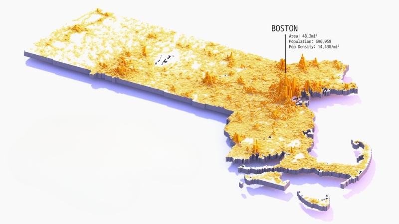
It is home to Plymouth, the site of the 1620 Pilgrim colony. Today, Massachusetts is the 3rd most densely populated state in the nation, despite being the 7th smallest.
It has a steady annual population growth rate of 0.75%, ranking 28th nationally.
The state’s population is primarily concentrated in two major metropolitan areas: Greater Boston, home to about two-thirds of the population, and the Springfield metropolitan area in the west. Massachusetts is the most populous and fastest-growing New England state.
With an area of 10,555 square miles (27,336 square kilometers) and an average population density of 839.4 people per square mile, Massachusetts maximizes its land use. Middlesex County is the largest in population, followed by Worcester County.
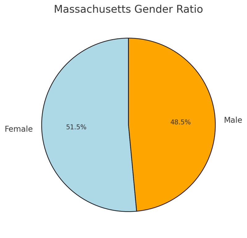
The state has a median age of 39.4 years, with a gender ratio of 51.5% female and 48.5% male. Religiously, 58% of the population identifies with Christian-based faiths, 9% with non-Christian faiths, and 32% are unaffiliated.
Massachusetts has seen significant demographic changes over the years. The non-Hispanic white population, which accounted for nearly 85% of the state in 1970, has declined due to migration and immigration from East Asia, Africa, and Latin America. The state is notable for its 3rd largest Haitian population in the U.S. and a significant Portuguese community.
Massachusetts was one of the 13 original states, and Maine was part of it until 1820, when it became a separate state. The current boundaries of Massachusetts were finalized after a border agreement with Rhode Island in 1862. Census coverage has included all areas of Massachusetts since the first U.S. census in 1790.
Racial Composition of Massachusetts (Recent ACS Data)
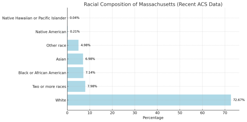
Massachusetts has seen significant demographic changes over the years. The non-Hispanic white population, which accounted for nearly 85% of the state in 1970, has declined due to migration and immigration from East Asia, Africa, and Latin America. The state is notable for its 3rd largest Haitian population in the U.S. and a significant Portuguese community.
Largest Cities in Massachusetts
The table below highlights the ten largest cities in Massachusetts by population. These cities serve as key economic, cultural, and administrative hubs within the state.
Rank
City
Population (2023)
Population (2022)
Population Density (per sq. mi.)
Area (sq. mi.)
Growth Rate
Type
1
Boston
654,423
653,243
13,538
48.3
0.09%
City
2
Worcester
209,566
205,676
5,609
37.4
0.94%
City
3
Springfield
153,337
154,007
4,811
31.9
-0.22%
City
4
Cambridge
119,008
117,420
18,604
6.4
0.67%
City
5
Lowell
114,401
114,191
8,406
13.6
0.09%
City
6
Brockton
104,889
104,891
4,917
21.3
0%
City
7
Lynn
101,603
100,879
9,461
10.7
0.36%
City
8
Quincy
101,380
101,814
6,117
16.6
-0.21%
City
9
New Bedford
100,757
100,633
5,038
20.0
0.06%
City
10
Fall River
94,044
93,636
2,839
33.1
0.22%
City
- Boston is the largest city and state capital, known for its historical landmarks and cultural significance. It has a moderate growth rate and is a dense urban center.
- Worcester, the second-largest city, is a hub for education and healthcare, experiencing a steady growth rate of 0.94%.
- Springfield, the third-largest, has a slight population decline but remains an important economic and cultural center in western Massachusetts.
- Cambridge stands out for its incredibly high population density, driven by institutions like Harvard University and MIT.
- Cities like Lowell, Brockton, and Lynn reflect Massachusetts’ rich industrial history, transitioning into modern urban centers.
Counties By Population 2024
County
Population (2023)
Growth Rate (%)
Area (sq. mi.)
Density (per sq. mi.)
Notable Cities
Middlesex County
1,631,110
0.18%
316
1,994
Lowell, Cambridge
Worcester County
870,859
1.3%
583
576
Worcester
Essex County
813,679
0.73%
190
1,650
Salem, Lynn
Suffolk County
768,038
-3.66%
22
13,242
Boston
Norfolk County
729,477
0.68%
153
1,842
Quincy, Brookline
Bristol County
583,938
1.24%
213
1,056
Fall River, Taunton
Plymouth County
537,368
1.35%
254
815
Plymouth, Brockton
Hampden County
459,824
-0.97%
238
745
Springfield
Barnstable County
231,392
1.48%
152
587
Barnstable, Falmouth
Hampshire County
162,486
10.82%
203
308
Amherst, Northampton
Berkshire County
126,089
-1.97%
358
136
Pittsfield, North Adams
Franklin County
70,677
-0.35%
270
101
Greenfield
Dukes County
20,676
0.4%
40
201
Martha’s Vineyard
Nantucket County
14,445
1.46%
18
314
Nantucket
Massachusetts has 14 counties, with Middlesex County being the most populous, home to 1,631,110 residents in 2023. It has seen a 7.1% increase in population since 2010 and includes notable cities like Lowell and Cambridge according to the World Population Review. Worcester County follows with 870,859 residents, centered around the city of Worcester.
Essex County has 813,679 residents and features historical cities like Salem and Lynn. Suffolk County, despite a slight population decline (-3.66%), remains densely populated, including Boston with a density of 13,242 people per square mile. Norfolk County and Bristol County also have populations exceeding 500,000.
Airports in Massachusetts
Airport Name
Location
IATA Code
Logan International Airport
Boston
BOS
Worcester Regional Airport
Worcester
ORH
Barnstable Municipal Airport
Hyannis (Barnstable)
HYA
Martha’s Vineyard Airport
West Tisbury
MVY
Nantucket Memorial Airport
Nantucket
ACK
New Bedford Regional Airport
New Bedford
EWB
Westover Metropolitan Airport
Chicopee (Springfield)
CEF
Pittsfield Municipal Airport
Pittsfield
PSF
Beverly Regional Airport
Beverly
BVY
Norwood Memorial Airport
Norwood
OWD
Taunton Municipal Airport (King Field)
Taunton
TAN
Lawrence Municipal Airport
Lawrence
LWM
Fitchburg Municipal Airport
Fitchburg
FIT
References
- World Population Review – Massachusetts Counties Population
Related Posts:
- Map of Texas - Cities, Geography, Counties & Stats (2025)
- Map of Pennsylvania - Cities, Geography, Counties &…
- Map of California - Cities, Geography, Counties &…
- Map of Colorado - Cities, Geography, Counties & Stats (2025)
- Map of Alaska - Cities, Geography, Counties & Stats (2025)
- Map of Georgia - Cities, Geography, Counties & Stats (2025)


