
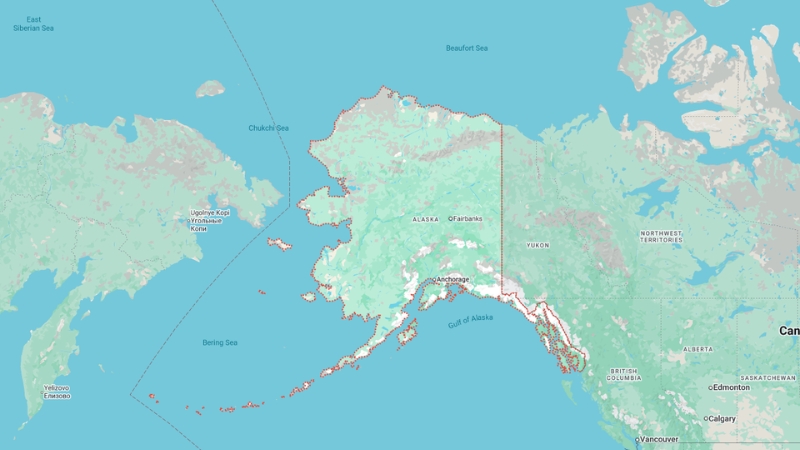
The largest U.S. state, Alaska, occupies a vast peninsula in the extreme northwest of North America.
Its impressive 10,690 km (6,640 mi) coastline spans the Arctic Ocean’s Beaufort and Chukchi Seas, the Bering Strait and Bering Sea, and the Gulf of Alaska in the Pacific Ocean.
Separated from the contiguous 48 states by Canada, Alaska is one of only two U.S. states not sharing a border with another state, the other being Hawaii.
To the east, Alaska borders Canada’s Yukon Territory and British Columbia, while its maritime border to the west touches Russia across the Bering Strait.
Known as “The Last Frontier,” Alaska’s unique geography and location make it a remarkable part of the United States.
Alaska State Map and Satelite View
The largest U.S. state, Alaska, occupies a vast peninsula in the extreme northwest of North America.
Its impressive 10,690 km (6,640 mi) coastline spans the Arctic Ocean’s Beaufort and Chukchi Seas, the Bering Strait and Bering Sea, and the Gulf of Alaska in the Pacific Ocean.
Separated from the contiguous 48 states by Canada, Alaska is one of only two U.S. states not sharing a border with another state, the other being Hawaii.
To the east, Alaska borders Canada’s Yukon Territory and British Columbia, while its maritime border to the west touches Russia across the Bering Strait.
Known as “The Last Frontier,” Alaska’s unique geography and location make it a remarkable part of the United States.
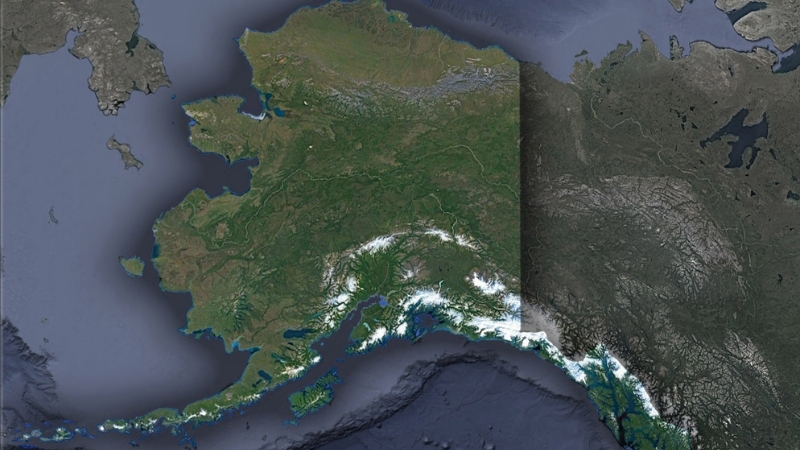
Geography Map of State
Alaska is bordered to the east by Canada’s Yukon and British Columbia, to the south and southwest by the Pacific Ocean and the Gulf of Alaska, to the west by the Bering Sea and the Bering Strait, and to the north by the Arctic Ocean.
The state shares a maritime border with Russia, with the two nations’ territories separated by just three miles (4.8 km) at the Bering Strait. With a coastline longer than all other U.S. states combined, Alaska’s shores span nearly 34,000 miles (55,000 km).
Alaska covers 663,268 square miles (1,717,856 km²), making it the largest state in the U.S. and over twice the size of Texas. It is larger than Texas, California, and Montana combined and ranks as the seventh-largest subnational division in the world. If Alaska were an independent country, it would be the 18th largest in the world, comparable in size to Iran.
Natural Features and Landmarks
Alaska boasts over 409,000 natural lakes and extensive wetlands, covering 188,320 square miles (487,700 km²). Glacier ice spans approximately 28,957 square miles (75,000 km²), with the Bering Glacier being the largest in North America. Tidal changes in Turnagain Arm, near Anchorage, can exceed 35 feet (10.7 m), among the highest in the world.
The Aleutian Islands and other coastal areas are home to numerous active volcanoes, including Mount Shishaldin and Mount Spurr. Alaska is part of Wrangellia, a geologically active region contributing to continental building in the Pacific Northwest.
Name
Type
Length (Miles) / Area (Square Miles)
Significance
Yukon River
River
1,980 miles
One of the longest rivers in North America; essential for transportation and wildlife habitat.
Kuskokwim River
River
702 miles
Vital for local communities; supports subsistence fishing and transportation.
Copper River
River
290 miles
Known for its salmon runs; significant for commercial and sport fishing.
Tanana River
River
584 miles
A major tributary of the Yukon; supports local ecosystems and human settlements.
Susitna River
River
313 miles
Potential site for hydroelectric projects; supports rich biodiversity.
Lake Iliamna
Lake
1,012 square miles
The largest lake in Alaska; critical habitat for salmon and other aquatic species.
Becharof Lake
Lake
453 square miles
The second-largest lake is important for wildlife, including migratory birds and fish.
Selawik Lake
Lake
404 square miles
Key habitat for migratory birds; supports subsistence fishing for local communities.
Tustumena Lake
Lake
73 square miles
Known for its pristine waters; supports tourism, fishing, and recreational activities.
Teshekpuk Lake
Lake
320 square miles
Vital wetland area for wildlife; key stopover for migratory birds.
Colville River
River
350 miles
Significant for oil exploration; supports Arctic wildlife and traditional activities.
Noatak River
River
425 miles
Part of the Noatak National Preserve; one of the largest undisturbed river basins.
Regions of Alaska
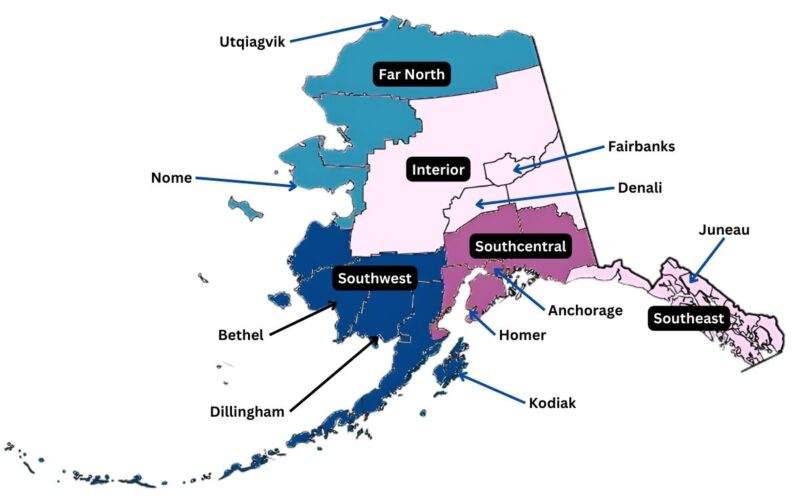
South Central
Anchorage, the most populous city, is located in this region, along with the Kenai Peninsula and Prince William Sound. This area is known for its accessibility and population density compared to the rest of the state.
Southeast (The Panhandle)
This region, close to the contiguous U.S., includes the capital city, Juneau, and the Tongass National Forest, the largest in the country. The Alaska Marine Highway connects this region, which is largely inaccessible by road.
Interior
The Interior region, characterized by vast wilderness, is home to Denali National Park and Denali (formerly Mount McKinley), North America’s highest peak. Fairbanks is the only significant city in this largely uninhabited area.
North Slope
Known for its tundra landscape and oil reserves, the North Slope includes the Prudhoe Bay Oil Field and Utqiaġvik, the northernmost city in the U.S. The region is sparsely populated and economically significant for its crude oil production.
Southwest
Southwest Alaska includes the Yukon–Kuskokwim Delta and portions of the Alaska Peninsula. The Aleutian Islands, known for their volcanic activity, are sometimes grouped with this region.
Aleutian Islands
This chain of over 300 volcanic islands extends 1,200 miles (1,900 km) into the Pacific Ocean. The islands cross the International Date Line, making them the westernmost and easternmost U.S. territories.
National Parks
Name
Established
Area (Square Miles)
Key Features
Denali National Park
1917
6,045
Home to North America’s highest peak, Denali; diverse wildlife and tundra ecosystems.
Gates of the Arctic NP
1980
13,238
Remote wilderness above the Arctic Circle; no roads or trails, untouched landscapes.
Glacier Bay National Park
1980
3,223
Renowned for tidewater glaciers, fjords, and marine wildlife.
Katmai National Park
1980
6,395
Famous for brown bear viewing and the volcanic “Valley of Ten Thousand Smokes.”
Kenai Fjords National Park
1980
669
Features the Harding Icefield, fjords, and abundant marine wildlife.
Wrangell-St. Elias NP
1980
20,587
Largest U.S. national park; encompasses glaciers, volcanoes, and mountain peaks.
Lake Clark National Park
1980
4,030
Combines mountains, coastline, and active volcanoes; a haven for wildlife.
Kobuk Valley National Park
1980
2,736
Known for Great Kobuk Sand Dunes and caribou migration.
Islands of Alaska
Alaska is home to approximately 1,800 named islands, with 1,000 of these located in the scenic Southeast region, often referred to as the Inside Passage. These islands vary widely in size, geography, and ecological importance.
- Kodiak Island: The largest in the state and the second-largest island in the United States, Kodiak Island is located in the Gulf of Alaska. It is separated from the mainland by the Shelikof Strait and spans an impressive 9,293 square kilometers (3,588 square miles), making it slightly larger than the island nation of Cyprus. The island is renowned for its lush landscapes, abundant wildlife, and the famous Kodiak brown bears.
- Aleutian Islands: This chain of over 300 volcanic islands stretches approximately 1,200 miles (1,931 km) into the Pacific Ocean, crossing the International Date Line. The Aleutians are significant for their rugged terrain, active volcanoes, and rich maritime ecosystems.
- Prince of Wales Island: Located in Southeast Alaska, this island is the fourth-largest in the U.S. Known for its dense rainforests and rich Indigenous heritage, it serves as a hub for fishing and forestry.
- Admiralty Island: Also in Southeast Alaska, Admiralty Island is famous for having one of the highest densities of brown bears in the world. It is a part of the Tongass National Forest and is known for its pristine wilderness.
A look at the Aleutian Islands, Alaska, from our satellite 🛰️ pic.twitter.com/OszqABiVrB
— sen (@sen) May 25, 2024
Glaciers of Alaska
View this post on Instagram
Alaska is home to an estimated 100,000 glaciers, collectively covering around 5% of the state’s total land area, or approximately 75,110 square kilometers (29,000 square miles). These glaciers play a crucial role in the state’s freshwater storage, with roughly three-fourths of Alaska’s freshwater held in glacial ice.
- Malaspina Glacier: Located in the St. Elias Mountains, southeast of Mount Saint Elias, the Malaspina Glacier is the world’s largest piedmont glacier. It spans approximately 2,200 square kilometers (850 square miles), roughly half the size of Rhode Island. The glacier forms a striking landscape where it spreads out as it reaches the coastal plain.
- Bering Glacier Complex: The largest glacier system in Alaska, the Bering Glacier complex, covers an area of 5,827 square kilometers (2,250 square miles). This system includes the Bagley Icefield, a vast expanse of interconnected glaciers and icefields.
- Mendenhall Glacier: Near Juneau, this glacier is one of Alaska’s most accessible and visited, offering a dramatic view of ice formations and meltwater streams. It serves as a stark example of climate change, as it has been receding over recent decades.
- Columbia Glacier: Located in Prince William Sound, this tidewater glacier is notable for its dramatic ice-calving events, where large chunks of ice break off into the ocean.
- Hubbard Glacier: The largest tidewater glacier in North America, Hubbard Glacier stretches over 122 kilometers (76 miles) and is still advancing, in contrast to many other glaciers in the region.
Land Ownership in Alaska
@erin.outdoors A few things you mist consider before sellimg wverything and moving to Alaska!!! Hope this video helps! Comment if tou want to know more OR if tou live here and have more to add! #lifeinalaska #alaskaliving #pnwlife #rainforestliving #pnwlife #movetoalaska #costoflivinginalaska #weatherinalaska #momsofinstagram #relocate ♬ original sound – Erin | 📷
Public Lands
Approximately 65% of Alaska is federally owned, including national parks, forests, and wildlife refuges. The Arctic National Wildlife Refuge is the largest in the world, covering 16 million acres (6.5 million hectares).
State and Private Lands
Alaska owns 101 million acres (41 million hectares) of land, and about 44 million acres (18 million hectares) are held by Native corporations under the Alaska Native Claims Settlement Act (ANCSA). Private landownership accounts for just 1% of the state.
Climate of Alaska
Location
July (°F)
July (°C)
January (°F)
January (°C)
Anchorage
65/51
18/10
22/11
−5/−11
Juneau
64/50
17/11
32/23
0/−4
Ketchikan
64/51
17/11
38/28
3/−1
Unalaska
57/46
14/8
36/28
2/−2
Fairbanks
72/53
22/11
1/−17
−17/−27
Fort Yukon
73/51
23/10
−11/−27
−23/−33
Nome
58/46
14/8
13/−2
−10/−19
Utqiaġvik
47/34
8/1
−7/−19
−21/−28
Alaska, the coldest state in the United States, is characterized by diverse climates ranging from Arctic in the far north to subarctic and oceanic climates in other regions. Its climate patterns are influenced by its vast size, geographic features, and proximity to oceans.
- Climate Type: Mid-latitude oceanic (Köppen: Cfb) and subarctic oceanic (Cfc).
- Characteristics: The warmest and wettest part of the state. Milder winters and high precipitation year-round.
- Precipitation: Juneau averages over 50 inches (130 cm) annually, while Ketchikan exceeds 150 inches (380 cm).
- Winter Temperatures: Daytime highs above freezing.
Population Heat Map
Alaska Population Density Maphttps://t.co/I4Bz7Byuy7 pic.twitter.com/npruBi27Eu
— Brilliant Maps (@BrilliantMaps) October 17, 2024
Recent data reveals that in 2024, Alaska’s population was recorded at 733,536, marking a slight increase from 2023 despite previous declines.
Alaska is the 48th most populous state in the U.S., but it stands as the largest by land area, covering an immense 665,384 square miles. This vast expanse makes Alaska the most sparsely populated state, with an average population density of only 1.2 people per square mile.
Urban centers in Alaska are limited, with just 29 cities and towns exceeding 1,000 residents. Anchorage, the largest city, had a population of 298,695 in 2015, ranking as the 82nd largest city in the U.S. Apart from Anchorage, only Juneau, the state capital (pop: 32,756), and Fairbanks (pop: 32,325) have populations exceeding 10,000.
Gender and Religious Composition
Alaska’s median age is 33.6 years, with a gender distribution of 47.7% females and 52.2% males. Regarding religious affiliation, 62% of Alaskans identify with Christianity, 6% with non-Christian faiths, and 31% claim no religious affiliation.
Boundary, Statehood, and Census History
The United States purchased Alaska from Russia in 1867, establishing its present boundaries. Initially criticized as “Seward’s Folly,” the acquisition proved valuable after gold was discovered in the Yukon in 1896, making Alaska a gateway to the Klondike gold fields. Alaska became a U.S. territory in 1912 and achieved statehood on January 3, 1959.
Alaska’s census history dates back to 1880. Unique to Alaska, the 1930 and 1940 censuses were conducted in the fall of the previous years, 1929 and 1939, respectively.
Racial Composition
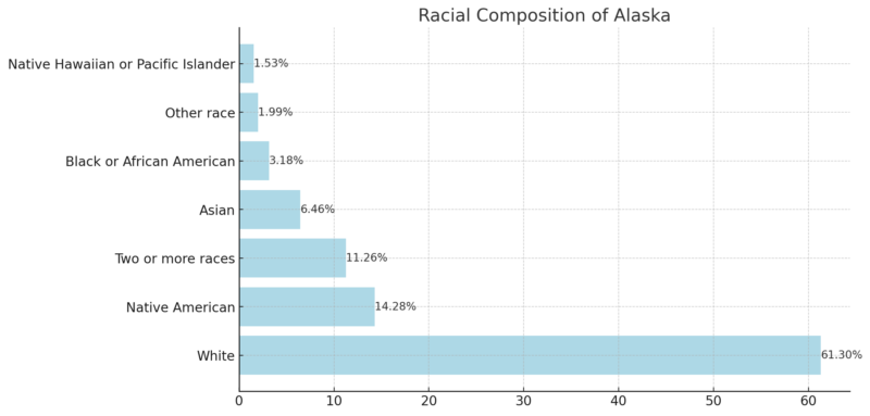
The majority of Alaska’s residents (61.3%) identify as White, reflecting the dominant racial demographic in the state.
Native Americans make up a notable 14.28% of the population, underscoring Alaska’s historical and cultural ties to Indigenous communities.
Individuals identifying as two or more races (11.26%) reflect the increasing multicultural nature of Alaska.
The Asian population accounts for 6.46%, representing the fourth-largest racial group in the state.
Black or African American (3.18%), other races (1.99%), and Native Hawaiian or Pacific Islander (1.53%) populations contribute to Alaska’s rich cultural diversity, though they form smaller portions of the overall population.
Largest Cities in Alaska
Rank
Place
2023 Population
2024 Population
Area (sq mi)
Density (per sq mi)
Growth Rate (%)
Type
1
Anchorage
284,469
286,983
167
1,707.0
-0.56%
Township
2
Fairbanks
31,674
31,994
998
31.7
-0.57%
City
3
Juneau
31,337
31,740
12
2,704.2
-0.69%
City and Borough
4
Knik-Fairview
19,235
18,619
262
73.5
1.63%
CDP
5
Badger
19,132
19,182
291
65.7
-0.13%
CDP
6
College
12,278
12,376
656
18.7
-0.4%
CDP
7
North Lakes
11,972
10,262
773
15.5
7.69%
CDP
8
Wasilla
10,223
9,702
825
12.4
2.79%
City
9
Tanaina
9,930
9,682
328
30.3
1.26%
CDP
10
Meadow Lakes
8,974
8,773
119
75.4
1.14%
CDP
- Anchorage Dominates: Anchorage is by far the largest populated area in Alaska, with a density significantly higher than any other place, highlighting its role as Alaska’s central urban hub.
- Sparse Distribution: Other cities like Fairbanks and Juneau have relatively low populations compared to Anchorage but maintain critical roles in Alaska’s economy and administration.
- Significant Growth: North Lakes shows the highest growth rate (7.69%), indicating rapid development in this CDP.
- Urban vs. Rural: Smaller cities and CDPs such as Meadow Lakes and Tanaina have lower densities, reflecting Alaska’s vast open spaces and rural nature.
- Population Decline: Slight population declines in Anchorage, Fairbanks, and Juneau suggest trends that could relate to economic, environmental, or migration factors.
Counties of Alaska
Name
Population
Growth Rate (%)
Area (sq mi)
Density (per sq mi)
Notes
Anchorage Municipality
285,167
-1.97%
659
167
Largest population in Alaska.
Matanuska-Susitna Borough
117,006
8.84%
9,500
5
Rapidly growing area.
Fairbanks North Star Borough
94,478
-0.9%
2,800
13
Includes Fairbanks, Alaska’s second-largest city.
Kenai Peninsula Borough
61,835
4.91%
6,200
4
Coastal borough with significant tourism.
Juneau City and Borough
31,370
-2.6%
1,000
12
Alaska’s state capital.
Bethel Census Area
18,189
-2.53%
15,700
0.45
Sparse population in a large area.
Ketchikan Gateway Borough
13,704
-1.52%
1,900
3
Known for its tourism and port activities.
Kodiak Island Borough
12,491
-4.26%
2,600
2
Home to Kodiak Island, rich in fisheries.
North Slope Borough
10,395
-5.53%
34,300
0.12
Largest area, focuses on oil production.
Nome Census Area
9,735
-2.93%
8,900
0.42
Sparse population in remote areas.
Sitka City and Borough
8,211
-2.55%
1,100
3
Historic city with strong cultural ties.
Kusilvak Census Area
7,788
-6.96%
6,600
0.46
Low population density in vast tundra.
Northwest Arctic Borough
7,269
-6.77%
13,800
0.20
Focus on resource extraction industries.
Southeast Fairbanks Census Area
7,138
4.65%
9,600
0.29
Growing population in a sparsely populated area.
Chugach Census Area
6,639
-6.23%
3,700
1
Known for scenic landscapes.
Prince of Wales-Hyder Census Area
5,742
0.02%
2,000
1
Remote communities with cultural significance.
Aleutians West Census Area
5,230
0.31%
1,700
1
Home to fishing industries.
Yukon-Koyukuk Census Area
5,089
-4.14%
56,200
0.03
Largest land area, extremely low density.
Dillingham Census Area
4,490
-7.19%
7,100
0.24
Declining population in fishing areas.
Aleutians East Borough
3,492
1.9%
2,700
0.50
Includes remote islands and communities.
Petersburg Borough
3,484
2.38%
1,100
1
Known for its fishing and small-town charm.
Copper River Census Area
2,739
4.78%
9,500
0.11
Isolated area with natural beauty.
Hoonah-Angoon Census Area
2,245
-4.79%
2,500
0.34
Small population with cultural heritage.
Haines Borough
2,070
-0.67%
905
1
Scenic area attracting tourists.
Wrangell City and Borough
2,057
-3.25%
987
1
Historic city with natural resources.
Denali Borough
1,593
-1.3%
4,900
0.13
Gateway to Denali National Park.
Lake and Peninsula Borough
1,285
-11.38%
9,200
0.05
Sparse population with declining numbers.
Skagway Municipality
1,098
-11.31%
168
3
Popular cruise ship destination.
Bristol Bay Borough
818
-1.45%
186
2
Center for salmon fishing.
Yakutat City and Borough
689
1.03%
2,900
0.09
Small population in remote areas.
Matanuska-Susitna Borough shows the highest growth rate (+8.84%), reflecting expanding suburban and semi-rural communities.
Areas like Kusilvak Census Area and Lake and Peninsula Borough face significant population declines, indicative of migration trends away from remote regions according to World Population Review.
Boroughs such as Yukon-Koyukuk and North Slope have extremely low densities, underscoring Alaska’s vast, uninhabited areas.
While Anchorage’s population slightly declined, it remains Alaska’s primary urban hub.
Boroughs like North Slope and Kodiak Island, despite lower populations, are vital due to oil and fishing industries.
Airports in Alaska
Airport Name
Location
IATA Code
Ted Stevens Anchorage International
Anchorage
ANC
Fairbanks International
Fairbanks
FAI
Juneau International
Juneau
JNU
Ketchikan International
Ketchikan
KTN
Kodiak Benny Benson State
Kodiak
ADQ
Sitka Rocky Gutierrez
Sitka
SIT
Nome Airport
Nome
OME
Bethel Airport
Bethel
BET
Barrow Wiley Post-Will Rogers Memorial
Utqiaġvik (Barrow)
BRW
Dillingham Airport
Dillingham
DLG
Kenai Municipal
Kenai
ENA
Kotzebue Ralph Wien Memorial
Kotzebue
OTZ
Petersburg James A. Johnson
Petersburg
PSG
Wrangell Airport
Wrangell
WRG
Yakutat Airport
Yakutat
YAK
Unalaska Tom Madsen (Dutch Harbor)
Unalaska (Dutch Harbor)
DUT
Cordova Merle K. (Mudhole) Smith
Cordova
CDV
King Salmon Airport
King Salmon
AKN
Deadhorse Airport (Prudhoe Bay)
Deadhorse
SCC
Alaska’s airports are strategically located across its vast and remote regions, ensuring access to even the most isolated areas.
Anchorage (ANC) and Fairbanks (FAI) serve as the main international and domestic hubs, connecting Alaska with the contiguous United States and international destinations.
Airports like Bethel (BET), Nome (OME), and Kotzebue (OTZ) play critical roles in connecting smaller, remote communities to larger hubs for essential services and supplies.
Airports like Dutch Harbor (DUT) and Kodiak (ADQ) are vital for industries like fishing and oil, reflecting their economic significance.
Many of Alaska’s airports face unique operational challenges due to extreme weather, requiring specialized facilities and management.