Florida is a southeastern U.S. gem that sits on a long, flat peninsula between the Atlantic Ocean on the east and the Gulf of Mexico on the west.
To the north, it shares borders with Alabama and Georgia.
As the southeasternmost state, Florida is a magnet for tourists and home to iconic destinations like Walt Disney World, Cape Canaveral and the Kennedy Space Center, Universal Orlando Resort, Miami Beach, the Everglades, Key West, and the beautiful Florida Keys.
Originally known as “La Florida” under Spanish rule, the territory was officially ceded to the United States in 1819.
It became Florida Territory and, on March 3, 1845, joined the Union as the 27th state.
Table of Contents
ToggleFlorida State Map and Satelite View
Florida covers an area of 65,758 square miles (170,312 square kilometers), making it the 22nd largest U.S. state by size.
To put this in perspective, Florida is roughly half the size of Finland and nearly twice as large as Maine.
Water bodies make up a significant portion of the state’s area—around 12,133 square miles (31,424 square kilometers)—which is almost 20% of Florida’s total area, giving the state an impressive blend of coastal, freshwater, and wetland ecosystems.
California remains the most populous state, though its population slightly declined by 0.19% from 2022 to 2023.
Texas and Florida saw the highest growth rates among the top ten states, with Florida’s population increasing by 1.62% and Texas by 1.55%.
New York experienced a notable population decrease of 3.16% since 2020, while Pennsylvania and Illinois also saw slight declines.
Florida Population Heat Map
Florida, with an estimated population of 21.6 million as of 2020, ranks as the third most populous state in the United States, following California and Texas according to Census.
But according to World Population Review in 2025 it has 22,975,900 residents.
This growing population is spread across a mix of urban centers, coastal communities, and rural areas, reflecting Florida’s diverse landscape and cultural mix.
Cities and Towns
Apalachicola
Islamorada
New Smyrna Beach
Arcadia
Jacksonville
Ocala
Avon Park
Jacksonville Beach
Okeechobee
Bartow
Jupiter
Orlando
Belle Glade
Kendall
Ormond Beach
Boca Raton
Key Largo
Pahokee
Bonita Springs
Key West
Palatka
Bradenton
Kissimmee
Palm Bay
Brooksville
Lake City
Palm Coast
Cape Coral
Lake Wales
Panama City
Clearwater
Lakeland
Pensacola
Coral Springs
Largo
Perry
Crestview
Leesburg
Pompano Beach
Dade City
Live Oak
Port Charlotte
Daytona Beach
Madison
Port St Joe
De Funiak Springs
Marathon
Port St Lucie
De Land
Marianna
Punta Gorda
Delray Beach
Melbourne
Sanford
Deltona
Merritt Island
Sarasota
Eustis
Miami
Sebring
Everglades City
Miami Beach
Spring Hill
Fernandina Beach
Moore Haven
St Augustine
Fort Lauderdale
Naples
St Petersburg
Fort Myers
New Smyrna Beach
Starke
Fort Pierce
Ocala
Tallahassee
Fort Walton Beach
Okeechobee
Tampa
Gainesville
Orlando
Titusville
Hialeah
Ormond Beach
Valparaiso
Hollywood
Pahokee
Vero Beach
Homestead
Palatka
West Palm Beach
Islamorada
Palm Bay
Winter Haven
Largest Cities
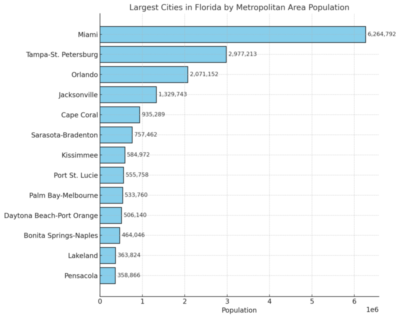
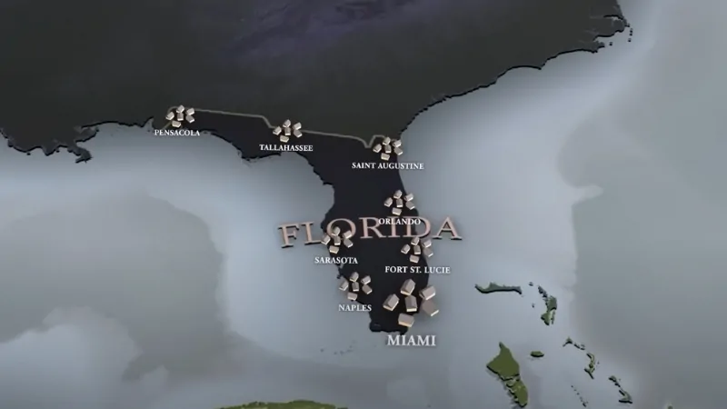
Florida’s largest metropolitan area, however, is the Miami-Fort Lauderdale-Pompano Beach area, home to approximately 6.1 million people, making it one of the most dynamic and internationally recognized regions in the state.
Other major cities include Miami, Tampa, Orlando, and St. Petersburg, all of which contribute to the state’s economic and cultural diversity.
English is the primary language spoken by approximately 70% of Floridians, while nearly 22% of the population speaks Spanish, reflecting the state’s substantial Hispanic and Latino communities.
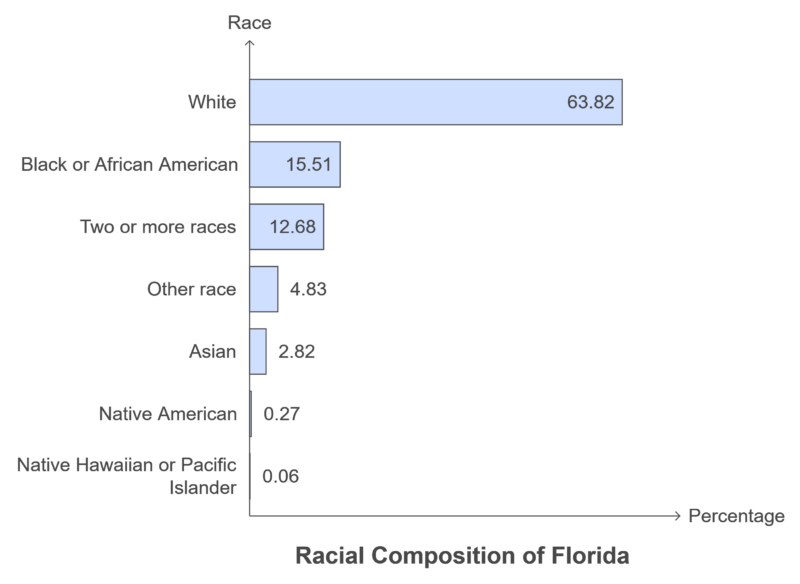
The racial composition of Florida based on the most recent data:
Counties
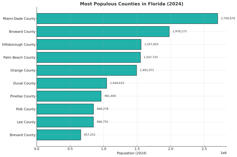
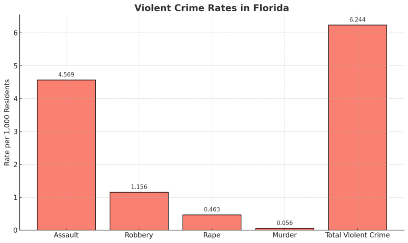
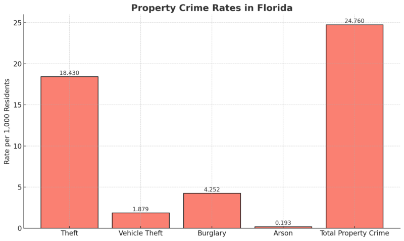
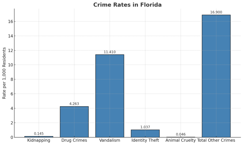
Florida is made up of 67 counties, from Alachua to Washington, listed here alphabetically. Covering an area of 65,758 square miles, Florida ranks as the third most populous state in the U.S. In the northern panhandle region, located in Leon County, is Tallahassee, Florida’s capital. Known for its role in education, Tallahassee serves as a key academic center for both the state and the country. Meanwhile, in northeastern Florida along the St. Johns River lies Jacksonville, the state’s largest and most populated city. These are the 10 most populous counties in 2024: Florida is known for its remarkably flat terrain, with its highest natural point, Britton Hill, reaching only 345 feet (105 meters) above sea level. Major attractions include the Florida Keys, Everglades, and Big Cypress Swamp. The state experiences a humid, subtropical climate, with annual rainfall averaging between 40 to 60 inches (101 to 152 cm). Florida’s unique landscape can be divided into four main geographical regions: the Coastal Plains, Everglades, North Central, and the Keys, each contributing to its ecological and cultural diversity. Covering a large portion of Florida, the Coastal Plains consist of flatlands with sandy and clay-rich soils that slope gently toward the Atlantic Ocean and Gulf of Mexico. Marshes and wetlands dominate this area, particularly in the Big Bend region of the panhandle, which remains sparsely populated due to its dense woodlands and marshes. Covering approximately 1.5 million acres, this tropical wetland is a sanctuary for numerous plant and animal species, including the West Indian Manatee, American Crocodile, American Alligator, and the endangered Florida Panther. The North Central region, located in northern Florida, stands out with gently rolling hills—a rare sight in the state. This area includes the state’s highest elevation at Britton Hill and is rich with pine forests, magnolia trees, and Spanish moss. The Florida Keys, an archipelago of over 1,700 islands extending from the southern tip of Florida, are among the most famous destinations for their tropical charm and diverse marine life. The Dry Tortugas National Park, covering 100 square miles (259 square kilometers), is a highlight in this region, offering a glimpse of vibrant coral reefs, marine biodiversity, and rare bird species. Florida is home to over 7,700 lakes, with Lake Okeechobee being the largest, covering roughly 730 square miles (1,891 square kilometers). The state also boasts an extensive network of rivers, stretching over 25,000 miles (40,000 kilometers) in total length. The longest of these is the St. Johns River, which spans more than 300 miles (483 kilometers) and has a unique feature: due to Atlantic tides, its flow reverses direction twice daily. The Suwannee River is the second-longest, measuring 246 miles (396 kilometers). Although the Miami River is much shorter at only about 5.5 miles (8.9 kilometers), it plays a key role in the city of Miami. Florida has more than 8,400 miles of coastline, with distinct ecosystems along the Gulf of Mexico and the Atlantic Ocean: This is the state with the highest concentration of freshwater springs in the world, with over 1,000 documented springs 1:40 p.m. Wednesday, October 9, 2024 — Florida Weather Center (@FLWeatherCenter) October 9, 2024 Florida shows the Köppen-Geiger climate zones, highlighting the state’s diverse climate regions. The majority of Florida falls under the humid subtropical (Cfa) zone, covering areas from northern Florida down through central parts, including cities like Tallahassee, Orlando, and Tampa. This zone is characterized by hot summers, mild winters, and significant humidity. In the southern tip, the climate shifts to tropical types: The state experiences warm temperatures year-round, with average summer highs reaching the 90s °F (32-37°C) and mild winters rarely dipping below 40°F (4°C) in the north. Annual rainfall varies, with central and southern Florida receiving around 60 inches (152 cm) per year, often from intense summer thunderstorms. Hurricane season, lasting from June to November, is particularly significant, as Florida is one of the most hurricane-prone states in the U.S. The southern coast and Keys are especially vulnerable, though hurricanes can impact the entire state. Florida spans two time zones: Eastern Time Zone (ET) and Central Time Zone (CT). Everglades National Park protects wetlands crucial for species like the American crocodile and Florida panther. Big Cypress National Preserve and Canaveral National Seashore offer undeveloped lands supporting wildlife and natural vegetation. Historical sites, such as Castillo de San Marcos and Fort Matanzas, feature colonial forts with historical reenactments. Gulf Islands National Seashore extends to barrier islands, while De Soto and Fort Caroline memorials recognize early European expeditions. Timucuan Ecological Preserve protects coastal wetlands and Timucua Native American sites, emphasizing cultural and ecological conservation. Florida’s network of airports provides seamless flights to its vibrant cities and attractions. Orlando International Airport (MCO), the busiest in the state, welcomes millions eager to explore Orlando’s theme parks and resorts. Miami International Airport (MIA) serves as a major hub for flights to Latin America and the Caribbean, while Fort Lauderdale–Hollywood International Airport (FLL) offers budget-friendly flights for South Florida visitors. Tampa International Airport (TPA) caters to those exploring the Gulf Coast, while Southwest Florida International (RSW) in Fort Myers connects travelers to the pristine beaches of southwest Florida. Jacksonville International (JAX) serves as the main gateway to the northeast coast, and Palm Beach International (PBI) efficiently handles flights to the Treasure Coast. Regional airports like Sarasota–Bradenton (SRQ), Pensacola (PNS), and Key West (EYW) add convenience, making flights across Florida’s diverse landscapes easy, enhancing the state’s popularity year-round. Florida’s safety is average compared to other U.S. states, earning a C grade. The state ranks in the 45th percentile for safety, meaning 55% of states are safer, while 45% are more dangerous according to Crimegrade. Within Florida’s boundaries, the crime rate stands at 47.90 incidents per 1,000 residents per year. Generally, residents consider the eastern part of Florida to be the safest, while areas in the southeast have higher crime rates. The most dangerous city in Florida is Belle Glade, with a violent crime rate of 1,310 per 100,000 people, which is 406% above the state average. On the rise is Marianna, with violent crime significantly above the state average at 1,183 per 100,000 people. This small city has long faced crime challenges, and recent data suggests a continued struggle with safety, placing Marianna high on the list of dangerous cities in Florida according to AreaVibes. Conversely, Orlando has seen fluctuations in crime, with a current rate of 836 violent crimes per 100,000 people. High crime rates in areas like retail districts, airports, parks, and schools can be misleading due to high visitor numbers in these locations. For instance: The breakdown below outlines crime rates per 1,000 residents in Florida according to crime grade:
Alachua
Baker
Bay
Bradford
Brevard
Broward
Calhoun
Charlotte
Citrus
Clay
Collier
Columbia
DeSoto
Dixie
Duval
Escambia
Flagler
Franklin
Gadsden
Gilchrist
Glades
Gulf
Hamilton
Hardee
Hendry
Hernando
Highlands
Hillsborough
Holmes
Indian River
Jackson
Jefferson
Lafayette
Lake
Lee
Leon
Levy
Liberty
Madison
Manatee
Marion
Martin
Miami-Dade
Monroe
Nassau
Okaloosa
Okeechobee
Orange
Osceola
Palm Beach
Pasco
Pinellas
Polk
Putnam
Saint Johns
Saint Lucie
Santa Rosa
Sarasota
Seminole
Sumter
Suwannee
Taylor
Union
Volusia
Wakulla
Walton
Washington
Geography
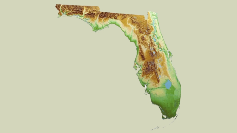
Relief Map of Florida
The Coastal Plains
The Everglades
Often called the “River of Grass,” the Everglades in southern Florida is one of the most iconic wetland ecosystems globally.North Central
The Florida Keys
Florida Rivers and Lakes
Fun Facts
Weather Map and Time Zones
Current radar of Hurricane 🌀 Milton. One huge band from Tampa to Key West. Many tornadoes 🌪 in all the bands. Stay safe. pic.twitter.com/7OL6D6rFKB
Florida National Parks Map
Florida’s National Park Service sites include diverse ecosystems and historically significant locations.Major Airports in Florida
Airport Name
Location
IATA Code
Orlando International Airport
Orlando
MCO
Miami International Airport
Miami
MIA
Tampa International Airport
Tampa
TPA
Fort Lauderdale–Hollywood International Airport
Fort Lauderdale
FLL
Southwest Florida International Airport
Fort Myers
RSW
Jacksonville International Airport
Jacksonville
JAX
Palm Beach International Airport
West Palm Beach
PBI
Pensacola International Airport
Pensacola
PNS
Sarasota–Bradenton International Airport
Sarasota/Bradenton
SRQ
Daytona Beach International Airport
Daytona Beach
DAB
Tallahassee International Airport
Tallahassee
TLH
St. Pete–Clearwater International Airport
St. Petersburg/Clearwater
PIE
Gainesville Regional Airport
Gainesville
GNV
Key West International Airport
Key West
EYE
Melbourne Orlando International Airport
Melbourne
MLB
Northwest Florida Beaches International Airport
Panama City
ECP
Orlando Sanford International Airport
Sanford
SFB
Crime Map
Violent Crimes (D+)
Property Crimes (B-)
Other Crimes (C-)
References:
Related Posts:


