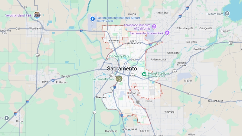
Sacramento, the capital of California, is located in the state’s Central Valley where the American River meets the Sacramento River, about 140 km (87 miles) northeast of San Francisco. Since 2015, California has ranked as the sixth-largest economy in the world.
Founded in 1840 by John Sutter, a Swiss immigrant, Sutter’s Fort became the first European settlement in California’s Central Valley.
The area grew into an economic hub during the California Gold Rush, serving as a key center for agriculture, trade, and transportation.
Sacramento became a major distribution point for wagon trains, stagecoaches, riverboats, and later, the terminus of the First Transcontinental Railroad. In 1854, Sacramento was designated as California’s state capital.
The Pony Express reached Sacramento in 1860 but was soon replaced by the First Transcontinental Telegraph in 1861.
Today, Sacramento is California’s sixth-largest city, with a population of approximately 490,000 as of 2015, and over 2.27 million people in the greater Sacramento metropolitan area.
The city’s economy is supported by transportation, healthcare, professional services, agriculture, and government.
Major employers include state and county agencies, healthcare providers, school districts, and Intel.
Table of Contents
ToggleGeography of Sacramento
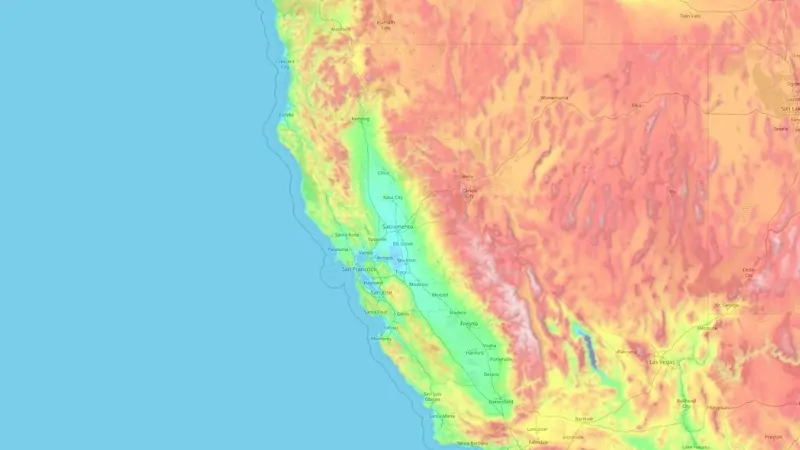
Sacramento is located in the heart of California’s Central Valley, one of the world’s most fertile and agriculturally significant regions. It sits at an average elevation of 9 meters (30 feet) above sea level, with some areas rising as high as 24 meters (79 feet).
The city covers a land area of approximately 259.27 square kilometers (100.09 square miles) and is bordered by Yolo County to the west, Placer County to the north, and El Dorado County to the east.
Its latitude and longitude are 38.5758° N and 121.4789° W. Sacramento is approximately 140 kilometers (87 miles) northeast of San Francisco, making it a critical link between the Bay Area and the Sierra Nevada region.
Feature
Value
Latitude/Longitude
38.5758° N, 121.4789° W
Elevation
Average: 9 m (30 ft); Max: 24 m (79 ft)
Land Area
259.27 km² (100.09 sq mi)
Population Density
~1,890 people/km²
Surrounding Counties
Yolo, Placer, El Dorado
Rivers
Two major rivers flow through Sacramento, shaping its geography and contributing significantly to its economy and recreation. The Sacramento River, California’s largest river, runs along the city’s western edge.
It spans 719 kilometers (447 miles) from the Klamath Mountains in the north to the Sacramento-San Joaquin Delta in the south. The river’s extensive watershed, covering 70,000 square kilometers (27,000 square miles), supports agriculture, transportation, and urban water supply.
The American River, a tributary of the Sacramento River, originates in the Sierra Nevada and flows westward into the city. Its 48-kilometer (30-mile) length includes the American River Parkway, a natural greenbelt used for outdoor activities like hiking, cycling, and kayaking.
River
Length
Features
Sacramento River
719 km (447 mi)
Irrigation, recreation, urban water source
American River
48 km (30 mi)
American River Parkway, recreational use
Trees and Parks
Sacramento is renowned for its extensive urban forest, earning the nickname “City of Trees.” The city boasts more than 100,000 publicly maintained trees, with many private trees further enriching the urban canopy. This coverage accounts for approximately 20% of the city’s area, providing shade and environmental benefits like reduced urban heat and improved air quality.
Sacramento is home to numerous parks, with Discovery Park being one of the largest. Located at the confluence of the Sacramento and American Rivers, this 302-acre park is a hotspot for fishing, picnicking, and water sports.
William Land Park, spanning 207 acres, offers attractions like the Sacramento Zoo and golf courses. The American River Parkway, stretching 37 kilometers (23 miles), provides a scenic route for outdoor enthusiasts.
Park
Size (Acres)
Notable Features
Discovery Park
302
River confluence, fishing, water sports
William Land Park
207
Zoo, golf course, picnic areas
American River Parkway
23 miles
Hiking, biking, scenic routes
Geology
Sacramento’s geological foundation consists primarily of sediments deposited by ancient inland seas and rivers.
These layers include clay, silt, sand, and gravel, which contribute to the area’s rich agricultural soil.
The city lies in a relatively low seismic activity zone compared to other parts of California, but it remains susceptible to distant impacts from faults in the Sierra Nevada and Bay Area.
Geology Feature
Description
Soil Composition
Clay, silt, sand, gravel
Seismic Activity
Low; distant fault zones may have an impact
Climate
The Winter Storm Warning will expire at 4 PM PST this afternoon as snowfall has tapered off. A few isolated light showers will be possible in the mountains over the next few hours with little to no additional accumulation/impacts expected. #CAwx
Roads: https://t.co/6jnhwJwK5a pic.twitter.com/LqMGfFIu0W
— NWS Sacramento (@NWSSacramento) November 26, 2024
Sacramento experiences a Mediterranean climate characterized by hot, dry summers and mild, wet winters.
The average annual rainfall is 19.87 inches (505 mm), with most precipitation occurring between November and March.
Summer temperatures often exceed 34°C (93°F), while winter lows average around 3°C (37°F). The city receives significant sunshine, with over 2,600 hours annually, making it a favorable location for outdoor activities.
Climate Metric
Value
Average Annual Rainfall
19.87 inches (505 mm)
Average Summer High
34°C (93°F)
Average Winter Low
3°C (37°F)
Annual Sunshine Hours
2,600+
Sacramento Population
Sacramento, located in Sacramento County, California, is the state’s capital and the county seat but not the largest city.
According to World Population Review as of 2025, the city’s population is 526,669, reflecting a modest growth rate of 0.05% annually and a 0.22% increase since the 2020 census, which recorded a population of 524,943. Sacramento’s population has grown significantly over time, increasing from 466,488 in 2010 and exceeding 501,000 in recent years making it one of the fastest growing in the US.
The city is part of the broader Sacramento metropolitan area, which spans seven counties and has an estimated population of 2.66 million, making it the fourth-largest metro area in California and the 27th-largest in the United States. Sacramento’s urban area has a population of 1.44 million much smaller than LA’s greater area.
Demographics and Economy
The median age in Sacramento is 35.2 years, with males averaging 34.5 years and females 36 years. The city has an average household income of $102,258, but 14.79% of residents live below the poverty line.
Racial Composition (Most Recent ACS Data)
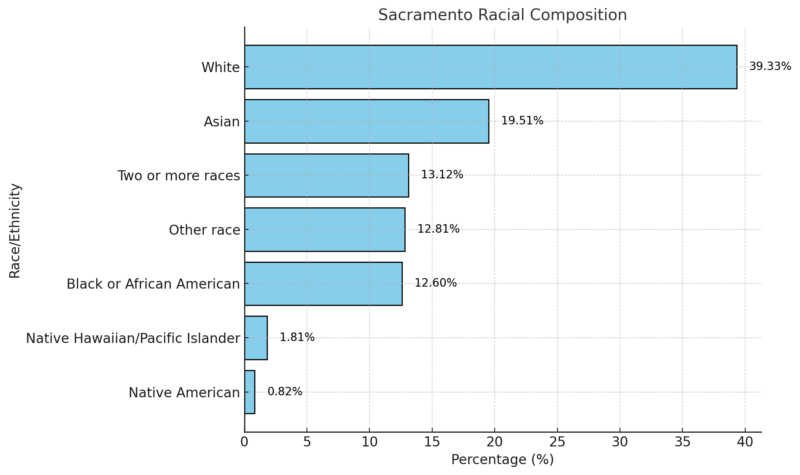
Sacramento has been recognized for its diversity. In 2002, Harvard University’s Civil Rights Project named it America’s Most Diverse City.
The city also has a notable LGBT community, ranking 7th in the United States and 3rd in California, with approximately 10% of residents identifying as gay, lesbian, or bisexual.
Historical Population Trends and Growth
Sacramento’s population has grown steadily since the mid-19th century. During the Gold Rush era in 1848, gold discoveries led to a rapid influx of settlers, boosting the city’s population to 10,000 despite challenges like cholera, floods, and fires.
Between 2000 and 2007, Sacramento added 164,000 residents, reflecting its continuing growth despite economic shifts, such as military base closures and declining agricultural activity.
Projected Growth

Sacramento is expected to see significant growth in the coming decades. By 2060, the city’s population is projected to reach 2.2 million, an increase of 54% from current estimates. The region has also been a focal point for California’s overall demographic changes, with the Hispanic population becoming the largest ethnic group in the state by 2020.
History and Early Settlement
The Sacramento Valley and River were named by Spanish explorer Gabriel Moraga between 1799 and 1832, inspired by the area’s vibrant atmosphere, likening it to “champagne.” Settlers arrived in 1839, establishing a trading colony. Sacramento became a charter city in 1920, granting it greater autonomy from state regulations.
The city’s early growth was fueled by Chinese immigration during the 1840s and 1850s. Chinese settlers, many of whom arrived during conflicts in China, first established themselves in San Francisco before moving to Sacramento.
Despite facing significant discrimination and the restrictive Chinese Exclusion Act (repealed in the 1940s), the Chinese community played an important role in the city’s development.
Attractions
Here are a few significant attractions you should visit when in Sacramento:
Old Sacramento State Historic Park
This historic district preserves buildings from the 19th century, showcasing Sacramento’s Gold Rush heritage.
The area features cobblestone streets, historic architecture, and attractions such as riverboat rides and horse-drawn carriages.
California State Capitol
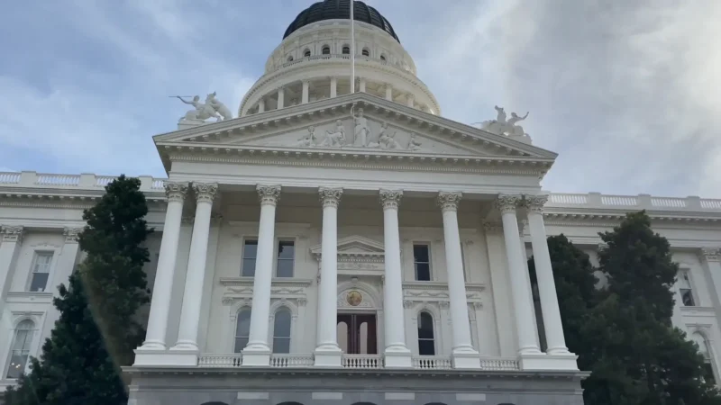
The capitol building houses the California State Legislature and the Governor’s office.
The first floor and basement feature the California State Capitol Museum, highlighting the state’s political and architectural history.
Sutter’s Fort
Narrative of Sutter’s Fort history could be changing | Click on the image to read the full story https://t.co/y1zOTo2Xen
— kcranews (@kcranews) June 11, 2024
Built in 1839, Sutter’s Fort, originally called New Helvetia, was a 19th-century agricultural and trade colony.
It played a pivotal role in the early settlement of Sacramento and served as a hub during the Gold Rush.
California State Railroad Museum
This museum focuses on the history of railroads and features restored historic locomotives and railroad cars.
It provides a glimpse into the role of trains in shaping California’s development.
California Automobile Museum
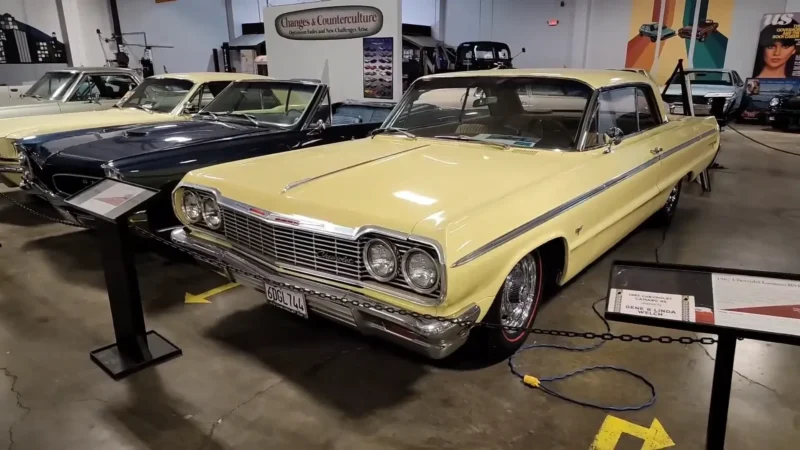
This museum showcases an extensive collection of classic, muscle, and race cars, offering insight into the evolution of the automobile industry.
The California Museum
As the official museum of the California State Archives, it houses the California Hall of Fame and exhibits on the state’s rich history and cultural diversity.
California State Indian Museum
Check out this week’s edition of our State Parks Weekly Digest! 🌟 https://t.co/lQMVMh7r5w
Highlights:
🎉 Congrats to the “Winter Bliss” contest winners!
🎨 New exhibition at the State Indian Museum
🚂 Historical train rides at the California State Railroad Museum and more! pic.twitter.com/eF8fcqLA8S— CA State Parks (@CAStateParks) March 16, 2024
This museum highlights the history and culture of California’s indigenous people, featuring artifacts and displays in a historic landmark building.
Sacramento History Museum
Dedicated to Sacramento’s history and the Gold Rush era, this museum offers exhibits and interactive experiences related to the city’s past.
Crocker Art Museum

The oldest continuously operating art museum in the West, the Crocker Art Museum features a renowned collection of fine art, ceramics, and contemporary works.
B Street Theatre
Sacramento’s B Street Theatre starts its run of ‘A Christmas Carol’ | Click on the image to read the full story https://t.co/Ue2Z4G9sAd
— kcranews (@kcranews) November 20, 2024
A popular venue for family and children’s theater, the B Street Theatre also showcases innovative performances and original plays.
Crest Theatre

This historic movie palace in downtown Sacramento hosts the Sacramento Film and Music Festival and has a legacy as a premier venue for independent films and events.
Cathedral of the Blessed Sacrament
Built in 1889, this Italian Renaissance-style cathedral is an iconic Sacramento landmark and serves as the mother church of the Sacramento Diocese.
Sacramento Zoo
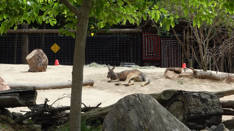
The zoo is home to giraffes, grizzly bears, orangutans, and over 500 animals. It plays a vital role in conservation and education efforts.
Sacramento National Wildlife Refuge
This expansive refuge is a haven for migrating birds and wildlife, offering opportunities for birdwatching and photography.
Folsom Lake
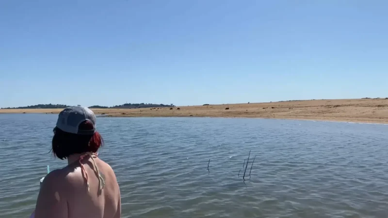
Located on the American River, this reservoir is a hub for recreational activities like boating, fishing, and hiking.
Golden 1 Center
This modern indoor arena is home to the Sacramento Kings NBA team and hosts concerts and events.
It is renowned for its environmentally sustainable design and central downtown location.
Raley Field
This baseball field in West Sacramento is home to the Sacramento River Cats, a minor league affiliate of the San Francisco Giants.
Hornet Stadium
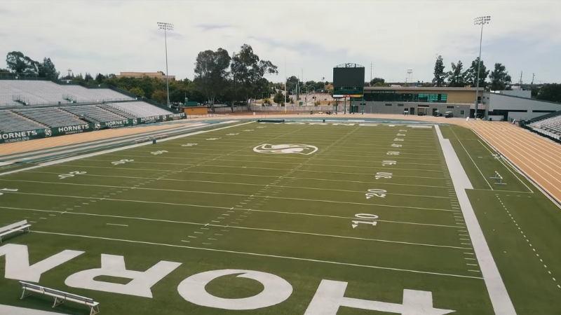
Located at Sacramento State University, this football stadium hosts college games, track events, and other sports activities.
California Exposition (Cal Expo)
Experience the rich culture, delicious food, and vibrant traditions of the Hmong community at the 2024 Sacramento Hmong New Year! 🎉✨ Join us at #CalExpo from November 29 to December 1. More details: https://t.co/HB2l1J5VJF pic.twitter.com/fqHY9MwJFz
— Cal Expo & CA State Fair (@CAStateFair) November 23, 2024
The site of the California State Fair, Cal Expo hosts numerous events year-round, including festivals, trade shows, and concerts.
Raging Waters Sacramento

This water park features thrilling slides, wave pools, and other attractions, making it a favorite destination for families.
Sacramento International Airport (SMF)
Located 18 kilometers (11 miles) northwest of downtown, this airport connects Sacramento to domestic and international destinations.
It is easily accessible via major highways.
Tower Bridge
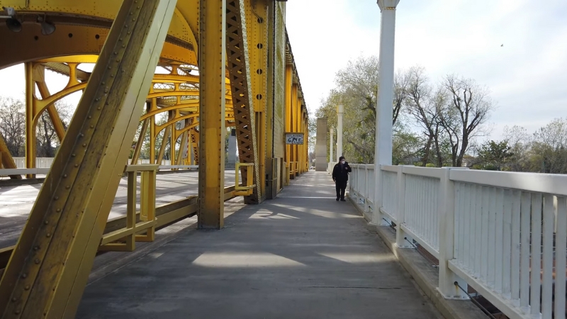
This iconic vertical-lift bridge connects West Sacramento and downtown.
Opened in 1935, it features Art Deco design and serves as a functional landmark and symbol of the city.
McKinley Park Rose Garden
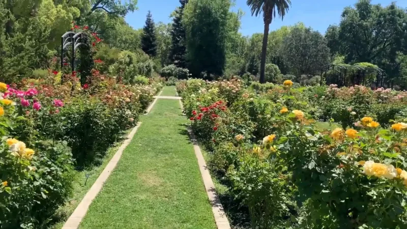
McKinley Park is a community favorite, known for its lush rose garden with over 1,200 rose bushes. The park also features playgrounds, sports fields, and walking paths.
Old City Cemetery
Established in 1849, Sacramento’s oldest cemetery is a historic site where many early pioneers and notable figures are buried. Its beautiful Victorian-era landscaping and historical tours make it a unique destination.
References:
- World Population Review – Sacramento Population 2024
- Neighborhood Scout – Sacramento Crime Data


