
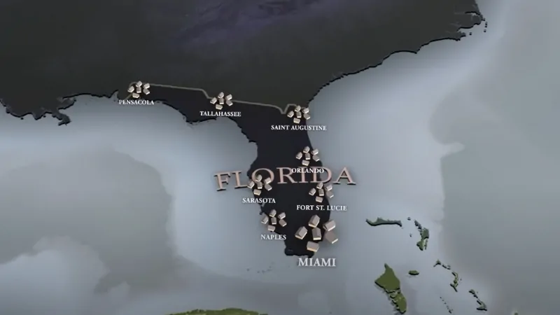
Florida is easy to recognize on a map. The long peninsula reaches between the Atlantic Ocean and the Gulf, the Panhandle stretches west toward Alabama, and the Florida Keys continue southwest from the mainland toward the Straits of Florida.
The population map is changing just as quickly as the physical map is familiar. The latest completed U.S. Census Bureau estimates put Florida at 23,462,518 residents on July 1, 2025, making it the third most populous state after California and Texas.
Florida added 196,680 people in a single year and has grown 8.9% from the 2020 estimate base. For a closer look at those demographic changes, our Florida population data breaks down the state in greater detail.
Growth is also moving around the map. South Florida remains the largest population center, but Central Florida, the Interstate 4 corridor, Polk County, Osceola County, Pasco County and communities along the northeast coast have become major parts of the growth story.
Florida State Map and Satellite View
Florida borders Georgia and Alabama to the north. The Atlantic Ocean forms the eastern coast, and the Gulf runs along the western side of the peninsula and Panhandle.
The Florida Department of State lists a total area of 65,758 square miles, including 53,625 square miles of land and 12,133 square miles of water. By total area, Florida ranks 22nd among the states.
Those numbers help explain why a simple outline map hides so much of the state. Florida contains extensive wetlands, thousands of lakes, long barrier islands, major estuaries and a coastline that changes character repeatedly between Jacksonville, Miami, Key West, Naples, Tampa Bay and Pensacola.
| Capital | Tallahassee |
| Population | 23,462,518 |
| 2020 Census population | 21,538,187 |
| Population growth since 2020 | 8.9% |
| Number of counties | 67 |
| Total area | 65,758 sq mi |
| Highest natural point | Britton Hill, 345 ft |
| Longest river | St. Johns River, 273 miles |
| Largest lake | Lake Okeechobee |
Florida Population
Florida has moved far beyond its old image as a state dominated by retirees and seasonal residents. Retirement migration still matters, but population growth now involves working-age households, international migration, expanding suburbs and rapidly growing inland communities.
The latest U.S. Census Bureau estimate places the population at 23,462,518. Florida gained 196,680 residents from 2024 to 2025, the second-largest numeric increase among the states after Texas.
An interesting change sits underneath that headline number. Recent Florida growth depends far more heavily on international migration than it did during the pandemic-era migration boom. Domestic migration remained positive in the latest Census estimates, but it accounted for a much smaller share of the increase than several years earlier.
That shift matters when reading a Florida population map. Growth is still substantial, but the sources of that growth have changed.
Largest Cities in Florida
Jacksonville remains the largest incorporated city in Florida. The Census Bureau estimated 1,017,689 residents in Jacksonville on July 1, 2025, putting it 11th among all U.S. cities.
City limits tell only part of the Florida story. Miami has fewer residents inside its municipal boundary than Jacksonville, yet the Miami-Fort Lauderdale-West Palm Beach metropolitan area is vastly larger and forms the main population concentration in South Florida.
Florida state estimates for April 2025 put several major cities at the following population levels:
| City | 2025 population estimate | Region |
|---|---|---|
| Jacksonville | More than 1 million | Northeast Florida |
| Miami | 478,799 | South Florida |
| Tampa | 412,684 | Tampa Bay |
| Orlando | 340,681 | Central Florida |
| St. Petersburg | 266,153 | Tampa Bay |
| Cape Coral | 222,862 | Southwest Florida |
| Tallahassee | 205,623 | North Florida |
Jacksonville, Miami, Tampa and Orlando also represent four very different versions of Florida. Jacksonville is geographically enormous and tied closely to northeast Florida. Miami is the international center of South Florida. Tampa anchors the western side of the peninsula. Orlando sits inland and has become one of the major engines of Central Florida growth.
Jacksonville occupies most of Duval County after city-county consolidation and stretches across a much larger land area than most American cities. Its growth has spread outward along Interstate 95, Interstate 10 and into neighboring St. Johns and Nassau counties.
Miami is much smaller geographically, but the surrounding urban region is one of the largest in the country. Miami-Dade, Broward and Palm Beach counties form a continuous urban corridor along the southeast coast.
Housing costs have also changed the old assumption that South Florida is a relatively inexpensive alternative to major northeastern cities.
Our analysis of the South Florida cost of living shows how expensive the region has become.
Tampa has expanded along with the wider Tampa Bay region. Growth now extends far outside the central city into Hillsborough, Pasco and Polk counties, creating a much larger commuter and housing market than the city boundary suggests.
Orlando had an estimated 340,681 residents in April 2025, but Orange County as a whole had more than 1.5 million. Nearby Osceola County has grown even faster in percentage terms. The Orlando region is therefore better understood as a broad Central Florida growth corridor than as a single city.
Tallahassee is the state capital and has a very different economic profile. State government, Florida State University and Florida A&M University give Leon County a strong public-sector and education presence compared with the tourism-heavy economy of Central Florida or the finance and trade economy of Miami.
Florida Demographics
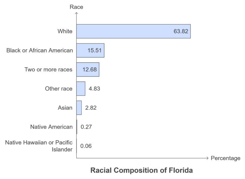
Florida is also older than the country as a whole. Current Census QuickFacts data show that 22.8% of residents are age 65 or older. That age structure is one reason Florida appears prominently in our comparison of U.S. states with the oldest populations.
The statewide number can be misleading, however. College communities such as Gainesville and Tallahassee are much younger. Retirement-heavy counties along the Gulf Coast and in Central Florida have much older populations. South Florida has another demographic profile again, shaped heavily by immigration from Latin America and the Caribbean.
Florida Counties
Florida has 67 counties. Miami-Dade is the largest by population, and Palm Beach County is the largest by area according to state records.
Full County List
| Alachua | Baker | Bay | Bradford |
| Brevard | Broward | Calhoun | Charlotte |
| Citrus | Clay | Collier | Columbia |
| DeSoto | Dixie | Duval | Escambia |
| Flagler | Franklin | Gadsden | Gilchrist |
| Glades | Gulf | Hamilton | Hardee |
| Hendry | Hernando | Highlands | Hillsborough |
| Holmes | Indian River | Jackson | Jefferson |
| Lafayette | Lake | Lee | Leon |
| Levy | Liberty | Madison | Manatee |
| Marion | Martin | Miami-Dade | Monroe |
| Nassau | Okaloosa | Okeechobee | Orange |
| Osceola | Palm Beach | Pasco | Pinellas |
| Polk | Putnam | St. Johns | St. Lucie |
| Santa Rosa | Sarasota | Seminole | Sumter |
| Suwannee | Taylor | Union | Volusia |
| Wakulla | Walton | Washington |
Largest Counties in Florida by Population
The chart above remains useful for seeing where population is concentrated. The latest statewide estimates now give us newer county figures. According to the Florida Legislature Office of Economic and Demographic Research, the ten largest counties in April 2025 were:
| Rank | County | 2025 population | Change since 2020 Census |
|---|---|---|---|
| 1 | Miami-Dade | 2,814,927 | +113,160 |
| 2 | Broward | 1,993,535 | +49,160 |
| 3 | Hillsborough | 1,575,637 | +115,875 |
| 4 | Palm Beach | 1,556,161 | +63,970 |
| 5 | Orange | 1,536,045 | +106,137 |
| 6 | Duval | 1,079,044 | +83,477 |
| 7 | Pinellas | 966,933 | +7,826 |
| 8 | Polk | 846,896 | +121,850 |
| 9 | Lee | 839,223 | +78,401 |
| 10 | Brevard | 667,900 | +61,288 |
Polk County stands out in that table. It added more residents than any of the other top ten counties between the 2020 Census and the April 2025 state estimate. The county sits between the Tampa and Orlando metropolitan areas, which helps explain why Lakeland, Winter Haven and surrounding communities have become important parts of the Interstate 4 growth corridor.
Osceola County provides an even more dramatic percentage-growth example. Its population rose from 388,656 in the 2020 Census to 484,915 in the April 2025 state estimate, an increase of more than 96,000 residents.
Geography of Florida
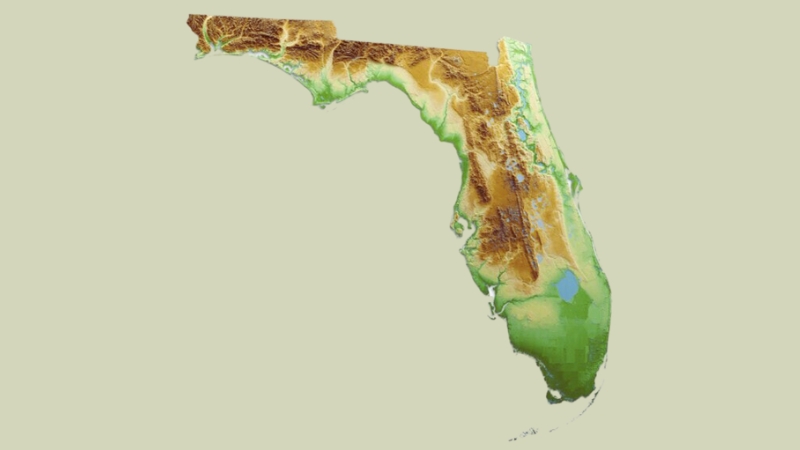
Florida is one of the flattest states in the country. Britton Hill in Walton County reaches only 345 feet above sea level. A visitor can drive hundreds of miles through Florida without seeing anything that resembles the mountain landscapes found farther north.
Flat does not mean geographically simple. The peninsula contains limestone, wetlands, sandy ridges, coastal plains, springs, estuaries, mangrove forests and the enormous Everglades system.
Coastal Plains
Low coastal plains cover much of the state. Barrier islands run along large sections of both coasts, with bays, lagoons and marshes sitting behind them. The Big Bend region in northwest Florida remains far less urbanized than the Tampa Bay or South Florida coasts.
The Everglades
The Everglades are not simply a swamp at the bottom of the map. They form part of a much larger water system connected to Lake Okeechobee and the historic flow of water south through the peninsula.
Everglades National Park protects a major part of that ecosystem, including sawgrass marshes, mangroves and habitat used by American alligators, American crocodiles, manatees and the endangered Florida panther.
North and Central Florida
Northern Florida has more elevation variation than the southern peninsula. Rolling terrain appears around the Panhandle and north-central counties, and the region contains large pine forests and major freshwater springs.
Central Florida contains a different landscape again. Lakes are everywhere, and the sandy ridges around Lake, Polk and Highlands counties sit well above much of the surrounding peninsula.
The Florida Keys
The Keys curve southwest from the mainland through Monroe County. Key West sits far closer to Cuba than most U.S. cities and marks the end of U.S. Route 1.
Dry Tortugas National Park lies about 70 miles west of Key West and is accessible primarily by boat or seaplane. The isolated location is part of the attraction. National Park Service data recorded 89,355 recreation visits to Dry Tortugas in 2025.
Rivers, Lakes and Springs
Lake Okeechobee is the largest lake in Florida and one of the dominant features on any physical map of the southern peninsula. The state lists its area at about 700 square miles.
The St. Johns River is the longest river entirely within Florida at roughly 273 miles. One detail surprises people seeing the river on a map for the first time: it flows north for much of its course before reaching the Atlantic near Jacksonville.
Florida also contains thousands of lakes and one of the largest concentrations of freshwater springs in the United States. Springs such as Silver Springs, Wakulla Springs, Ichetucknee Springs and Weeki Wachee are connected to the limestone aquifer beneath much of the state.
Water is therefore both a geographic advantage and a long-term challenge. Aquifer protection, saltwater intrusion, flooding and Everglades restoration are all tied directly to the same geology that produced the springs, wetlands and low coastal landscape.
Climate and Time Zones
Most of Florida has a humid subtropical climate, with hot summers, mild winters and a pronounced summer rainy season. South Florida becomes tropical, particularly around Miami, the Keys and parts of the southwest coast.
Hurricane season runs from June 1 through November 30. Geography makes the entire peninsula exposed to tropical systems from more than one direction. Storms can approach from the Atlantic, Caribbean or Gulf, and a hurricane that enters one Florida coast can cross the peninsula and affect the other.
Florida also spans two time zones.
- Eastern Time covers most of the state, including Jacksonville, Orlando, Tampa, Miami and Tallahassee.
- Central Time applies to the western Panhandle, including Pensacola and communities farther west.
The time-zone boundary is easy to overlook on a road map. Drivers heading west through the Panhandle eventually gain an hour without leaving Florida.
National Parks and Federal Sites in Florida
Florida has three national parks: Everglades, Biscayne and Dry Tortugas. The wider National Park Service network also includes Big Cypress National Preserve, Canaveral National Seashore, Castillo de San Marcos, Fort Matanzas, De Soto National Memorial and several other protected historic and natural sites.
National Park Service data for 2025 recorded 778,198 visits to Everglades National Park, 486,567 to Biscayne National Park and 89,355 to Dry Tortugas. Canaveral National Seashore received almost 2.5 million visits, while Big Cypress recorded more than 2.2 million.
The figures show how differently people experience public land in Florida. Everglades and Dry Tortugas are destination parks. Canaveral, Big Cypress and Gulf Islands also function as major recreation areas for nearby residents and visitors.
Major Airports in Florida
| Airport | City or region | IATA |
|---|---|---|
| Orlando International Airport | Orlando | MCO |
| Miami International Airport | Miami | MIA |
| Fort Lauderdale-Hollywood International Airport | Fort Lauderdale | FLL |
| Tampa International Airport | Tampa | TPA |
| Southwest Florida International Airport | Fort Myers | RSW |
| Jacksonville International Airport | Jacksonville | JAX |
| Palm Beach International Airport | West Palm Beach | PBI |
| Pensacola International Airport | Pensacola | PNS |
| Sarasota-Bradenton International Airport | Sarasota / Bradenton | SRQ |
| Key West International Airport | Key West | EYW |
| St. Pete-Clearwater International Airport | Pinellas County | PIE |
| Northwest Florida Beaches International Airport | Panama City area | ECP |
Florida airport geography follows the population map closely. Orlando handles the huge Central Florida visitor market, Miami is a major international gateway to Latin America and the Caribbean, Fort Lauderdale serves the dense South Florida corridor, and Tampa connects the large Gulf Coast population center.
Regional airports matter more than their size suggests. Sarasota, Fort Myers, Pensacola, Jacksonville and West Palm Beach allow visitors to reach different parts of a state that stretches hundreds of miles from the Panhandle to Key West.
Florida Crime Map
Crime maps need more care than simple state rankings suggest. A rate calculated for a residential neighborhood is not directly comparable with a tourist district, entertainment center, airport area or downtown zone that receives enormous numbers of visitors every day.
Population also varies dramatically across Florida. Miami-Dade has more than 2.8 million residents, while Liberty County has only a few thousand. A small change in the number of offenses can therefore move a rate sharply in a small community.
For current comparisons, the best starting point is the FBI Crime Data Explorer, where users can examine reported violent and property crime data by state and agency rather than relying on a single generalized safety score.
Violent Crime
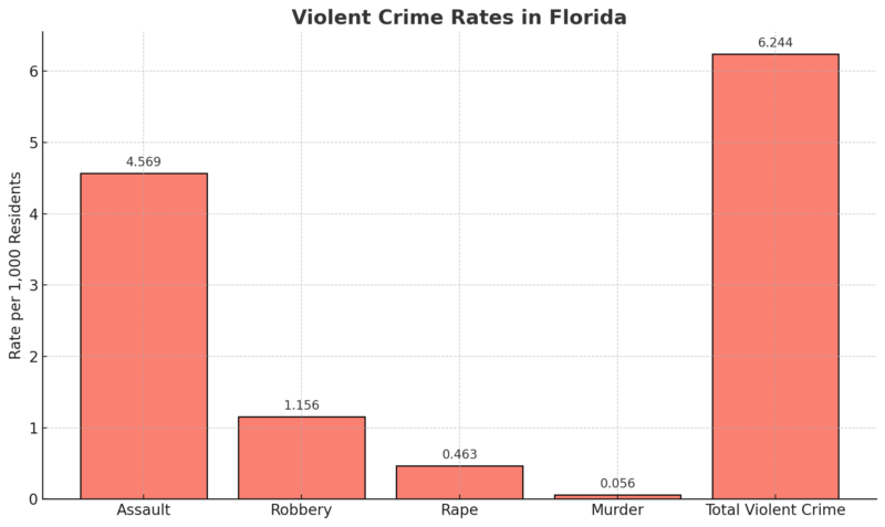
Violent crime maps are most useful for identifying broad concentrations, but city comparisons should use the same year, reporting method and population basis. Comparing numbers drawn from different datasets can create a ranking that looks precise but is not statistically consistent.
Property Crime
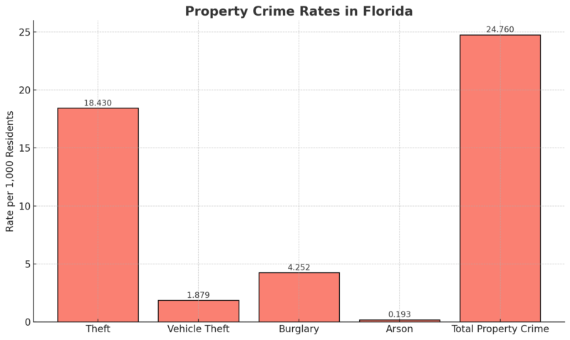
Property crime also has a strong geographic component. Retail centers, tourism districts and areas with large daytime populations can report many incidents relative to the number of people who officially live there.
Other Reported Crime
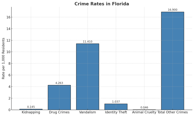
A useful Florida crime map should therefore be read alongside local agency data rather than treated as a definitive ranking of safe and unsafe places.
Bottom Line
Florida in 2026 is a state of 23.46 million people spread across 67 counties, with most residents concentrated in a few major metro areas and some of the fastest growth now happening through Central Florida and the surrounding suburban counties.